Porto Longosardo (Santa Teresa Gallura Sardegna)

Porto Longosardo (Santa Teresa Gallura Sardegna)

To precisely geolocate this site. Update if necessary.

Localisation

Porto Longosardo (Santa Teresa Gallura Sardegna)
LatitudeLongitude
DMS------
DM------
DD------

Characteristics

Port
Mooring
Sand
VHF canal 12, 16, 06,09,73
Water
Phone
Electricity
Fuel
First aid
Mechanical repair
Shipyard
Worn oil containers
Waste water collection
Slip
Shower
Wifi
WC
Market
Restaurant
Isolated danger
Weather forecast

Description

Porto Longosardo  (Santa Teresa Gallura Sardegna)
2007-07-11
Update
Mobile
Porto Longosardo  (Santa Teresa Gallura Sardegna)
2012-09-03
Update
Joëlle
Porto Longosardo  (Santa Teresa Gallura Sardegna)
2012-09-03
Update
Joëlle
Porto Longosardo  (Santa Teresa Gallura Sardegna)
2012-09-03
Update
Joëlle
Porto Longosardo  (Santa Teresa Gallura Sardegna)
2012-09-03
Update
Joëlle
Ebook

Sardegna North East

  • 156 sites
  • 349 photos
  • publication date: 11 Jul 2023
  • .pdf file size: 66 Mb
7 MN S Capo Pertusato, in the "Bouches de Bonifacio",  is 
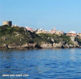
the nearest port when coming from Corsica. Porto Pozzo is a small village in the municipality of Santa Teresa Gallura, the furthest point north of Sardinia, Corsica face.
At the time of the Roman Empire, Santa Teresa Gallura (Longonis) was the main port of Sardinia with its deep fiord (the deepest of Mediterranean).

Santa Teresa is called Lungoni by the natives, a name that dates back to long before its creation by King Victor Emmanuel. Lungoni comes from "Porto Longone", oblong shame port, starting today of the tray that connects Sardinia to Corsica and departure of 5 or 6 boats tourism that offer, in the summer, a visit to the neighboring islands, in the context of Natural Park of La Maddalena.It is also a marina, whose places are expensive.

Today the ancient harbor is the largest natural landing and most comfortable of Sardinia, with approximately 700 berths; Longosardo harbor is protected from all winds except those from NW.

It is expedient to contact the seaport management on VHF channe 12 before the seaport entrance.

  • 750 b. (<35 m)
  • tel: 0789-754602
  • Mail: santateresagallura@guardiacostiera.it
2012/11/23
Update
Joëlle
A 7 milles au sud du cap Pertusato, dans les Bouches de Bonifacio, c'est le port le plus proche quand on vient de Corse. Porto Pozzo est un petit bourg de la commune de Santa Teresa Gallura, le point le plus au nord de la Sardaigne, face à la Corse.
Au temps de la domination romaine, Santa teresa Gallura (Longonis) était port principal de Sardaigne grâce à son profond fiord (le plus profond de la Méditerranée). 

Santa Teresa est appelée Lungoni par les autochtones, une dénomination qui remonte à bien avant sa création par le roi Victor Emmanuel. Lungoni vient de Porto Longone, le port de forme oblongue, aujourd'hui départ du bac qui relie la Sardaigne à la Corse et départ des 5 ou 6 bateaux de tourisme qui proposent, en été, une visite des iles voisines, dans le cadre du Parc Naturel de La Maddalena. C'est aussi un port de plaisance, dont les places sont chères.

Aujourd'hui l'antique port constitue l'atterrissage naturel le plus grand et le plus confortable de la Sardaigne, avec environ 700 places; le port de Longosardo est préservé de tous les vents sauf ceux de NW.

Il est conseillé de contacter la direction du port sur VHF 12, avant d'entrer dans le port.

  •   750 pl. (<35 m)
  • tel: 0789-754602
  • Mail: santateresagallura@guardiacostiera.it

Attention aux deux hauts-fonds de chaque côté de l'entrée du port, sous seulement 3,5m d'eau. Ils sont marqués par une balise verte avec voyant triangulaire et une balise rouge avec voyant carré.
A l'entrée du port rester au centre du canal et avancer à 3 noeuds maximum.
2012/11/23
Update
Joëlle
A 7 MN S di Capo Pertusato, nelle Bocche di Bonifacio, è il porto più vicino venendo dalla Corsica. Porto Pozzo è un piccolo villaggio nel comune di Santa Teresa Gallura, punto più a nord della Sardegna, volto Corsica.
Al tempo dell'Impero Romano, Santa Teresa di Gallura (Longonis) è stato il principale porto della Sardegna con il suo fiordo profondo (il più profondo del Mediterraneo).

Santa Teresa erai chiamato  Lungoni dai nativi, un nome che risale a molto tempo prima della sua creazione da parte di re Vittorio Emanuele. Lungoni viene da  Porto Longone, porto oblungo, oggi, partenza dei 5 o 6 barche che collegano la Sardegna alla Corsica e offrono nel periodo estivo, una visita alle isole vicine, nel contesto della parco naturale della Maddalena. E 'anche un porto, i cui posti sono costosi.

Oggi l'antico porto costituisce l'approdo naturale più grande e confortevole della Sardegna, con circa 700 posti barca; il Porto Longonsardo è riparato da tutti i venti salvo quelli di NW.

Ai tempi della dominazione romana Santa Teresa Gallura (Longonis) era il primo porto principale della Sardegna, grazie al suo profondo fiordo.

E' opportuno contattare la direzione del porto sul canale VHF 12 prima dell'ingresso in porto.

  • 750 pb.(<35 m)
  • tel: 0789-754602
  • Mail: santateresagallura@guardiacostiera.it

Attenzione alle due secche di 3,5m davanti all'imbocaturadel porto segnalate da due mede elstiche munite di fanali lambeggianti;
Durante l'ingresso in porto mantenersi al centro del canale e procedere con velocità non superiore a 3 nodi.
2012/11/23
Update
Joëlle
Share your comments or photos on "Porto Longosardo (Santa Teresa Gallura Sardegna)"

Sites around Porto Longosardo (Santa Teresa Gallura Sardegna)

Flying distances - Direct line

Senetose - Tizzano

25nm
315°
SW of Corsica offers some of the most beautiful anchorages. As you get closer to Bonifacio be carreful with the weather forecast as the NW  wind can be very strong.

The range of the tide in this area is negligible. There are no regular currents along the coasts of Corse, ...
15 May 12
dd

Isola La Maddalena (Arcipelago della Maddalena)

9.5nm
93°
It is the largest island of the archipelago composed of sixty islets and 7 major islands, in the NE end tip of Sardinia. It is mountainous and arid. This is the only inhabited island thoroughly.
It is connected by a bridge to Caprera island where are the house and the tomb of Garibaldi. ...
26 Nov 12
Joëlle

Golfe de Porto Vecchio

22nm
14°
La tourelle Pecorella marque l'entrée de ce golfe qui s'enfonce à plus de 4 M dans les terres. Celle de Chiapino qui était plus au S est démolie. Il faut donc remonter suffisamment vers le N pour ne pas risquer d'en toucher les restes.
En piquant vers l'W, la balise noire délimite ...
10 Jul 20
azerty

Golfo Di Arzachena (Sardegna)

13nm
120°
Gulf of Arzachena (Arsachena), located between Punta Saline and Tre Monti Cape, is a high inlet whose banks are lined with shoals.
S tip, Arzachena, W of the entrance, a beacon consists of an iron post with a sheer spherical white marks a rock particularly ...
8 Sep 12
Joëlle

Spiaggia Rena Bianca (Sardegna)

0.3nm
300°
Santa Teresa has a very beautiful white sandy beach, Rena Bianca, with a view on Bonifacio (Corsica) reefs, splendid still busy.

 You can anchor for the day, to the sixteenth century Spanish tower that marks the entrance of the port of Longosardo between the island and ...
23 Nov 12
Joëlle