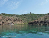
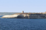
Pozzo or Su Puttu tower is an hispanic watchtower on a point carved by natural erosion that forms a corridor in the rock that joins the sea and can be visited by divers.
Behind the promontory lies Torre del Pozzo town.
2012/11/12
Update
Joëlle
La tour Pozzo ou tour Su Puttu est une tour de guet hispanique sur une pointe creusée par l'érosion naturelle qui a formé un couloir dans la roche qui rejoint la mer et peut être visité par les plongeurs.
Derrière le promontoire s'étend la ville Torre del Pozzo.
2012/11/12
Update
Joëlle
Torre Pozzo o torre Su Puttu è una torre d'avvistamento ispanica su una punta scavata dall'erosione naturale che a creato uno corridorio nella roccia che raggiunge il mare e puo essere visitato dai sub.
Dietro il promontorio si trova la città di Torre del Pozzo.
Coastal Pittinuri tower is located on a limestone promontory at 28 m above sea level and takes the name of the town of Santa Caterina di Pittinuri the territory of Cuglieri.
The tower was built around 1578 on the ledge where she could stay in visual contact with the towers ...
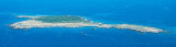
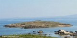
Mal di Ventre island takes its name the difficulties encountered by sailors to navigate its waters. Located opposite the Peninsula del Sunis, low and flat, 18 m high, it has an area of 80 hectares. A light is shown from a structure, 4m high, standing on the summit of the ...
The park begins at Capo Galera to continue toward the gulf of Porto Conte that is protected by two promontories, Punta Giglio and Capo Caccia-Monte Timidone. The marine protected area embraces the stretch of sea to the north-west of Punta Cristallo.Almost all of the park consists ...
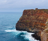
The capo Nieddu spanish tower is 1 km on a tip after the beautiful and single cascade throughout the region formed by the river Mannu, which flows into the sea from its 40 m high.
Situated on the cliff at 68 m above sea level, the Nieddu tower is in visual contact with the ...
Foghe cape is a small volcanic rock promontory that is N Nieddu cape and S Bosa, bordered to S by Mannu river.Foghe tower stands on the NW side of the point and is remarkable. The Cuglieri city and cathedral are 4.5 NM E of the tower and are clearly visible from the sea


 Pozzo or Su Puttu tower is an hispanic watchtower on a point carved by natural erosion that forms a corridor in the rock that joins the sea and can be visited by divers.
 La tour Pozzo ou tour Su Puttu est une tour de guet hispanique sur une pointe creusée par l'érosion naturelle qui a formé un couloir dans la roche qui rejoint la mer et peut être visité par les plongeurs.
 Torre Pozzo o torre Su Puttu è una torre d'avvistamento ispanica su una punta scavata dall'erosione naturale che a creato uno corridorio nella roccia che raggiunge il mare e puo essere visitato dai sub.
")
")
")