Tiruchendur Point (Tamil Nadu-E India)

Tiruchendur Point (Tamil Nadu-E India)

To precisely geolocate this site. Update if necessary.

Localisation

Tiruchendur Point (Tamil Nadu-E India)
LatitudeLongitude
DMS------
DM------
DD------

Characteristics

Description

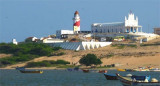
Tiruchendur Point is a low, rocky bluff headland, with a prominent dark-colored temple, 54m high, at its extremity. This pagoda is a useful mark and can be seen for a distance of about 15 miles.
A conspicuous chimney, 28m high, painted in red and white bands and emitting a flame, lies about 5 miles NNW of the point. In 1976, a depth of 14m was reported 9.3 miles ESE of the point.

From Tiruchendur Point to abreast the fishing village of Punnaikkayal, about 8 miles N, the coastal reef extends about 2.3 miles offshore. In heavy weather, the sea breaks on this reef in depths of 4.6 to 5.5m; usually it breaks farther inshore in depths of 3.7m.

2012/03/20
Update
Jojo
Tiruchendur Point (Tamil Nadu-E India)
2012-03-20
Update
Jojo
Ebook

Bay of Bengal

  • 110 sites
  • 82 photos
  • publication date: 7 Jul 2023
  • .pdf file size: 53 Mb
Share your comments or photos on "Tiruchendur Point (Tamil Nadu-E India)"

Sites around Tiruchendur Point (Tamil Nadu-E India)

Flying distances - Direct line

Punnaikkayal (E India)

8.1nm
Punnaikkayal, about 1 mile inland, can be identified by the ruins of a church and by a group of palmyra trees on the beach.
A 4.6m patch lies about 3 miles E of the village.Anchorage in 7.3m, can be found off Punnaikkayal, about 1.5 miles offshore, with the clump of trees bearing ...
20 Mar 12
Jojo

Manappad Point (SE India)

8.4nm
210°
Manappad Point is a high sandy promontory with a rock base. A light is shown from a white, round concrete tower with red diagonal stripes.
The village of Manappad lies 0.8 mile W of the point.
Manappad Outer Shoal, with a least depth of 6.4m, lies about 8 miles SE of Manappad ...
20 Mar 12
Jojo

Kariya Shuli and Vilangu Shuli islets (Pattanamarudur-E India)

28nm
16°
The town of Pattanamarudur, with some large trees visible up to 10 miles offshore, lies at thehead of this bight, about 7 miles N of Tuticorin.
The bight is filled by a flat, with depths of less than 5.5m, extending up to about 4.5 miles offshore. Kariya Shuli and Vilangu Shuli, ...
20 Mar 12
Jojo

Tuticorin

18nm
Port protected by a breakwater.
27 Mar 12
attributes

Chidambaranar (Tuticorin) Port (E India)

16nm
20°
Tuticorin (Tuttukuddi) is the largest commercial town on the W side of the Gulf of Mannar.Chidambaranar Port is an artificial deep-sea harbour formed with rubble mound type parallel breakwaters projecting into the sea for about 4 km. (Length of North breakwater is 4098.66 m, length ...
20 Mar 12
Jojo

East Cape (E India)

27nm
229°
East Cape is prominent, and the coastal reef, with depths of 5.5m, extends about 1 mile offshore near the cape.AnchorageShelter from W winds can be found in the bight between Cape Comorin and East Cape, but during the Southwest Monsoon landing by ship’s boats should not be attempted ...
19 Mar 12
Jojo