Punnaikkayal, about 1 mile inland, can be identified by the ruins of a church and by a group of palmyra trees on the beach.
A 4.6m patch lies about 3 miles E of the village.
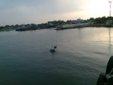
Anchorage in 7.3m, can be found off Punnaikkayal, about 1.5 miles offshore, with the clump of trees bearing 258° remaining clear of the dangerous wreck N of the anchorage.
The coastal reef to the S provides shelter from S winds, but local knowledge is necessary.
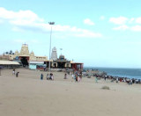
Tiruchendur Point is a low, rocky bluff headland, with a prominent dark-colored temple, 54m high, at its extremity. This pagoda is a useful mark and can be seen for a distance of about 15 miles. A conspicuous chimney, 28m high, painted in red and white bands and emitting a flame, ...
The town of Pattanamarudur, with some large trees visible up to 10 miles offshore, lies at thehead of this bight, about 7 miles N of Tuticorin. The bight is filled by a flat, with depths of less than 5.5m, extending up to about 4.5 miles offshore. Kariya Shuli and Vilangu Shuli, ...
Tuticorin (Tuttukuddi) is the largest commercial town on the W side of the Gulf of Mannar.Chidambaranar Port is an artificial deep-sea harbour formed with
rubble mound type parallel breakwaters projecting into the sea for
about 4 km. (Length of North breakwater is 4098.66 m, length ...
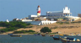
Manappad Point is a high sandy promontory with a rock base. A light is shown from a white, round concrete tower with red diagonal stripes. The village of Manappad lies 0.8 mile W of the point. Manappad Outer Shoal, with a least depth of 6.4m, lies about 8 miles SE of Manappad ...
East Cape is prominent, and the coastal reef, with depths of 5.5m, extends about 1 mile offshore near the cape.AnchorageShelter from W winds can be found in the bight between Cape Comorin and East Cape, but during the Southwest Monsoon landing by ship’s boats should not be attempted ...


 Punnaikkayal, about 1 mile inland, can be identified by the ruins of a church and by a group of palmyra trees on the beach.