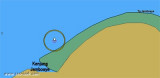

Ug Hagu (N Sumatra)
3nm
119°
21 Jan 12
Jojo
| Latitude | Longitude | |
| DMS | --- | --- |
| DM | --- | --- |
| DD | --- | --- |

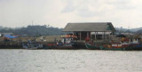
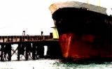
 Arun Marine Terminal is situated at Blanglancang Harbor.
In the approach to Blanglancang Terminal there are eight prominent storage tanks. About 0.8 mile to the SW of the terminal there are four conspicuous flares.
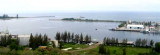
The refinery is serviced by two offshore mooring areas, as well as berthing facilities inside the harbor.A General Cargo Berth is situated along the W side of the basin between the two LNG berths. This berth is 400m long, with a depth of 6m alongside.
The LPG Dock, situated on the E side of the basin, is 270m long, with a depth of 14m alongside. It can accommodate a vessel up to 65,000 dwt, with a length of 255m and a draft of 13m.The offshore oil-loading berths consist of a Multiple Buoy Mooring (MBM) and a Single Point Mooring (SPM), lying 0.5 mile and 1.5 miles offshore. The MBM can accommodate tankers up to 100,000 dwt, with a maximum length of 275m.
The SPM will accept vessels of up to 280,000 dwt.
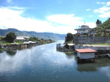
Vessels are restricted from berthing during night time at Lhokseumawe/Ug Hago Wharf or Blanglancang SBM/MBM. Blanglancang Harbor is open for 24 hour service.
Vessels are not allowed to proceed to the Blanglancang MBM restricted area without permission.
")
Ebook | Andaman sea
|