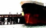
Old Lhokseumawe Harbor has a small pier 60m long, with a 2.4m depth alongside. Only barges and small vessels under 500 dwt can berth there.
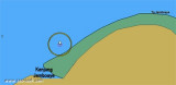
Old Lhokseumawe Harbor can be readily identified by a ridge of hills, 152m high, clear of trees and grass covered.
Channel depth in LHOKSEUMAWE old harbour for general cargo and Tugs/barges is 11 metres. LHOKSEUMAWE port control, Pilot & ship agents VHF channel 12.
ACCOMODATION:
Largest vessel 10,000 dwt 175m loa Berth Length (m) Depth (m) Cargo Public Berth 80 x 2 10 General Cargo AAF-A 195 10 Fertilizers in bulk B 300 10 Fertilizers in bag PIM 195 10 Fertilizers in bulk Hagu 25 5 Fuel oil
Ug Hagu consist of a single quay with a length of 20m, a width of 5m, and a depth alongside of 7m. Vessels are restricted from berthing during night time at Lhokseumawe/Ug
Hago Wharf or Blanglancang SBM/MBM. Blanglancang Harbor is open for 24
hour service.
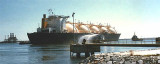
Arun Marine Terminal is situated at Blanglancang Harbor. In the approach to Blanglancang Terminal there are eight prominent storage tanks. About 0.8 mile to the SW of the terminal there are four conspicuous flares.The refinery is serviced by two offshore mooring areas, as well ...
Limitations.—Five berths in Kruenggeukueh Harbor handle bulk fertilizers and general cargo. These berths are described counter clockwise, beginning at the fertilizer plant situated on the W side of the harbor, as follows: 1. Berth A is 200m long, with a depth of 10m alongside. The ...
Tengah, a coral reef, has a least depth of 7.5m and depths from 21.9 to 25.6m around it. The reef lies 5 miles offshore, with Tanjung Jambuair bearing 100°, distance 7.3 miles. Minyak, a 16.5m patch, lies 2 mile NNW of Tengah.
Krueng Jambuair (Djambo Aje or Jamboaye) flows into the sea about 1 mile WSW of Tanjung Jambuair. The sea usually breaks over the bar at LW, with discolored water from the river sometimes extending as much as 4 miles from the mouth.


 channel 16
 25 tons
 Old Lhokseumawe Harbor has a small pier 60m long, with a 2.4m depth alongside. Only barges and small vessels under 500 dwt can berth there.
")