| Latitude | Longitude | |
| DMS | --- | --- |
| DM | --- | --- |
| DD | --- | --- |


Ebook | Istrie (Istra)
|
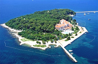
 The island protects the Porec bay.
The first Istrian town to acknowledge the Venetian rule was Porec in 1267. In the Porec port, there used to be a building that served as accommodation for pilots, experts who welcomed the ships heading towards Venice, boarded and guided them further to the Venetian lagoons. To ensure the navigation safety, the Venetians built a light house in 1403 on a small island near Porec (island of St. Nikola).
The first inhabitants of the island were most probably the priests who built the church of St. Anastasia in the 9th century. The Benedictines from the monastery of St. Nikola in Venice came to the island in the 12th century, and the island was later named after it. Since St. Nikola is the patron of sailors, the island was frequented by sailors and the owner of boats and ships, who prayed here for calm sea and peaceful navigation. The Benedictines gave them "the Miracle working medallion" with St. Nikola and Porec on one side.
By the end of the 18th century, after the fall of Venice, the family Polesini bought the island. The church deteriorated slowly, and in 1887 it was demolished and replaced with a luxurious summer house built by Benedetto Polesini (renewed some thirty years ago).
 Cette île protège la baie de Porec.
La première ville d'Istrie à reconnaître la domination vénitienne a été Porec en 1267. Dans le port de Porec, il y avait un bâtiment qui servait de logement pour les pilotes, les experts qui accueillaient les navires qui se dirigeaient vers Venise. Ils montaient à bord et les guidaient dans la lagune vénitienne. Afin d'assurer la sécurité de la navigation, les Vénitiens ont construit un phare en 1403 sur une petite île près de Porec (île de St. Nikola).
Les premiers habitants de l'île ont été probablement les prêtres qui ont construit l'église de Sainte-Anastasie au IXème siècle. Les bénédictins du monastère de Saint-Nikola à Venise vinrent sur l'île au XIIème siècle, et l'île a plus tard été nommée St Nikola. Depuis Saint-Nicolas est le patron des marins, l'île a été fréquentée par les marins et les propriétaires de bateaux et navires, qui ont prié ici pour avoir une mer calme et une navigation pacifique. Les bénédictins leur a donné «le médaillon du travail Miracle» avec Saint-Nicolas et Porec sur un côté.
À la fin du XVIIIème siècle, après la chute de Venise, la famille Polesini a acheté l'île. L'église s'est détériorée lentement, et en 1887 elle a été démolie et remplacée par une maison de vacances de luxe construit par Benedetto Polesini (renovée il y a trente ans).


