Rt Prostina à Rt Od Volam
5.4nm
139°
There are few bays between Rt Prostina and Rt Od Volam that defines N Premantura Peninsula.
2 Sep 11
Jojo
| Latitude | Longitude | |
| DMS | --- | --- |
| DM | --- | --- |
| DD | --- | --- |


")
Ebook | Istrie (Istra)
|
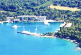
 The Brijuni or the Brijuni Islands (also known as the Brionian Islands; Italian: Brioni) are a group of fourteen small islands in the Croatian part of the northern Adriatic Sea, separated from the west coast of the Istrian peninsula by the narrow Fazana Strait. The largest island, Veliki Brijun Island- Brioni Grande or Veli Brijun (5.6 km2), lies 2 km off the coast, the others are Mali Brijun, San Marco, Gaz, Okrugljak, Supin, Supinic, Galija, Grunj, Krasnica (Vanga), Madona, Vrsar, Jerolim and Kozada. Famous for their scenic beauty, the islands are a holiday resort and a Croatian National Park.
Access to the Brioni Islands are forbidden to foreign vessels. Any underwater activity is prohibited in inland watersto a distance of about 3 million of these islands, due to the presence of cables between the islands and islets in W. It is also a training area for submarines.
Ebook | Šibensko-kninska županija (Šibenik-Knin County)
|
 L' archipel de Brioni, ou des Brijuni, (Briyuni) est un groupe de 14 petites îles au N de la Croatie dans la mer Adriatique. Elles sont situées au nord-ouest de Pula qui se trouve au bout de la presqu'île d'Istrie en Croatie. Cet archipel compte deux grandes îles dont la plus grande s'appelle Grand Brioni (5.6 km²) et treize plus petites et s'étend avec la mer environnante sur une surface de 36 km².
Entre Rt Barbariga et Rt Prostina (Pointe Crsito) les îles Brioni débordent la côte, à 6 M environ au SSE. Elles sont séparées de la côte par le canal de Fasana (Fazanski Kanal). Ce dernier est large de 1,8 M à son entrée au NE et de 1 M à son entrée S.
L'accès aux îles Brioni est interdit aux navires étrangers. Toute activité subaquatique est interdite dans les eaux intérieures et jusqu'à une distance d'environ 3 M de ces îles, en raison de la présence de câbles posés entre les îles et les îlots à l'W. C'est aussi un zone d'exercices de sous-marins.
Le Parc national de Brioni abrite des espèces animales et végétales rares, et un jardin zoologique avec des animaux exotiques.