On the plus side the state maintains a series of five mooring buoys off the key's NW shoreline. There is also plenty of room to anchor. Good depths of 6 feet or better are maintened to within 100 yards of the isle's NW banks. This anchorage field affords good shelter to the east, southeast, and south. The charted shoal and mangrove SW of Shell Key contributes to this protection greatly. On the other hand, don't get caught beside Shelle Key in strong northerlies, or even worse, blows coming from the NW.
2012/04/16
Update
JB
L'état maintient une série de cinq bouées de mouillage au large de la clé sur le littoral NW. Il ya aussi beaucoup de place à l'ancre. De bonnes profondeurs de 1,8 m ou plus sont maintenues à moins de 100 mètres des banques NW de l'île. Ce domaine offre un bon abri à l'E, SE et S. Les hauts-fonds et mangrove au SW de Shell clé contribuent grandement à cette protection. Attention de ne pas se faire prendre à côté de Shell clés par les vents forts du N, ou pire encore, du NW.
Long Key was called Cayo Vivora (Rattlesnake Key) by early Spanish explorers, a reference to the shape of the island, which resembles a snake with its jaws open, rather than to its denizens. In the early 20th century, Long Key was the site of a luxurious fishing resort that ...
The island lies to the southwest of Upper Matecumbe Key, and to the northeast of Craig Key. All of the key is within the Village of Islamorada as of November 4, 1997, when it was incorporated. This key is the site of a number of Indian mounds and middens, most of which were ...
Shell Key is a large, all-natual body of land that is found S of the ICW's unlighted daybeacon #91. It also lies near the Northerly head various passages. Shell Key is owned by the state of Florida and is fully protected. landings are not allowed.
Lignumvitae Key is an island in the upper Florida Keys. It is located due north of, and less than one mile from the easternmost tip of Lower Matecumbe Key. The island has the Keys' highest point above sea level of 19 feet (5.8 m), which beats the island of Key West's Solares ...
Key Vaca is an island in the middle Florida Keys, located entirely within the borders of the city of Marathon, Florida. It is often incorrectly identified as "Marathon Key."Key Vaca is located between Fat Deer Key and Knight's Key. Key Vaca is also connected via bridge to ...
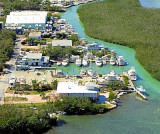
Coral Bay Marina lies off the Florida Straits. At buoy #R84 in the Florida Bay steer a course of 150°. 35 slips with 10 transients (< 60 feet) Reservations are required Depth: 5,5 to 6 feet Phone: 305 664 3111 Fax: 305 664 4281


 On the plus side the state maintains a series of five mooring buoys off the key's NW shoreline. There is also plenty of room to anchor.
 L'état maintient une série de cinq bouées de mouillage au large de la clé sur le littoral NW. Il ya aussi beaucoup de place à l'ancre.