Sardegna North West

Sardegna North West

To precisely geolocate this site. Update if necessary.

Localisation

Sardegna North West
LatitudeLongitude
DMS------
DM------
DD------

Characteristics

Sea

Description

The Gulf of Asinara has no particular difficulty outside the Mistral blows particularly hard.
The Asinara was declared National Park and homes a penitentiary. The Fornelli pass, located between Asinara island and Piana island, can be very dangerous in rough seas and at night. Piana Island is lined with dangerous rocks and Pelosa pass is shallow.

Pelosa bay is beautiful and worth at seen.

Porto Torres, large commercial and industrial port is a major port which connects with a summer line, the French mainland to Sardinia. Castelsardo harbour below the pretty village of the same name, is not protected from the winds of N / NW that generate high, cross-swell at the entrance of the harbor.

Isola Rossa and small harbor close this area of NW Sardinia.
2014/04/18
Update
Siandro
Le Golfe de l'Asinara ne présente pas de difficulté particulière en dehors du Mistral qui y souffle particulièrement violemment. 

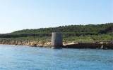
L'île Asinara a été déclarée parc National et abrite un pénitencier. La passe des Fornelli, située entre l'île Asinara et l'île Piana, peut être très dangereuse par mer agitée et la nuit. L'île Piana, est bordée de rochers dangereux et la passe de la Pelosa est peu profonde.

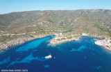
La rade de La Pelosa est de toute beauté et vaut le détour.

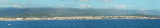
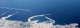
Porto Torres, grand port commercial et industriel, est l'un des principaux ports qui relie, avec une ligne d'été, la Sardaigne au continent français. Le port de Castelsardo, aux pieds du joli village du même nom, n'est pas abrité des vents de N/NW qui génèrent une forte et dangereuse houle traversière à l'entréè du port.

L'Isola Rossa et son petit port clôture cette zone NW de la Sardaigne.

2014/04/18
Update
Siandro
Il golfo dell'Asinara  non presenta particolari difficoltà, a parte il maestrale spesso violento.

L'isola Asinara è stata dichiarata parco nazionale e sede di un penitenziario. Il passo dei Fornelli, che si trova tra l'isola dell'Asinara e quella di Piana puo essere molto  pericoloso con mare mosso e durante la notte. L'isola Piana è francheggiata da rocce pericolose e il passo Pelosa è poco profondo.

Il porto di La Pelosa è magnifico e vale la pena di visitarlo.

Porto Torres, grande porto commerciale e industriale, è un importante porto che collega con una linea estiva, la Sardegna al continente francese. Porto Castelsardo ai piedi del bellissimo villaggio con lo stesso nome, non è protetta dai venti di N / NW che generano una barra pericolosa di traversia all'entrata del porto.

L'isola Rossa e il suo porticciolo chiuse questa zona NW della Sardegna.

2014/04/18
Update
Siandro
Ebook

Sardegna North West

  • 26 sites
  • 60 photos
  • publication date: 11 Jul 2023
  • .pdf file size: 14 Mb
Share your comments or photos on "Sardegna North West"

Sites around Sardegna North West

Flying distances - Direct line

Golfo dell'Asinara

2.3nm
304°
The Gulf Asinara opens between Caprara tip, N-terminus of Asinara island, and Tramontana point. Meanwhile W is formed by Asinara island. Its S side is low and sometime swampy.S Punta Negra Stintino harbour offers a good shelter.Between the coast and Asinara island, is Piana island, ...
22 Nov 12
Joëlle

Area Marina Protetta di Capo Caccia - I. Piana (Sardegna)

24nm
212°
The park begins at Capo Galera to continue toward the gulf of Porto Conte that is protected by two promontories, Punta Giglio and Capo Caccia-Monte Timidone. The marine protected area embraces the stretch of sea to the north-west of Punta Cristallo.Almost all of the park consists ...
20 Nov 12
Joëlle

Senetose - Tizzano

39nm
22°
SW of Corsica offers some of the most beautiful anchorages. As you get closer to Bonifacio be carreful with the weather forecast as the NW  wind can be very strong.

The range of the tide in this area is negligible. There are no regular currents along the coasts of Corse, ...
15 May 12
dd

Rada di Alghero (W Sardegna)

23nm
201°
Rada di Alghero is entered between S, the town of Alghero and N, capo Galera.The E shore of this bay is low and sandy, and the W shore is hilly and rocky.
An undulating coastal plain, partly under cultivation, lies immediately inland of the head of this bay.This bay is open to ...
16 Nov 12
Joëlle

Porto Torres (Sardegna)

6.6nm
211°
Located on a promontory on the north coast of Sardinia, overlooking the Gulf of Porto Torres this great commercial port in the Gulf, is a major port, that connects with a line of summer, Sardinia to the mainland French.
Holiday spot since Roman times already, the city has an extraordinary ...
22 Nov 12
Joëlle