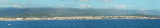

Isola dell' Asinara (Sardegna)
8.9nm
307°
This island has been declared National Parc. It is a narrow territory stretching from North to South, with a very indented coastline, which ...
7 May 14
Joëlle
| Latitude | Longitude | |
| DMS | --- | --- |
| DM | --- | --- |
| DD | --- | --- |

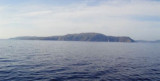
 The Gulf Asinara opens between Caprara tip, N-terminus of Asinara island, and Tramontana point. Meanwhile W is formed by Asinara island. Its S side is low and sometime swampy.
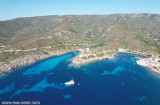
S Punta Negra Stintino harbour offers a good shelter.
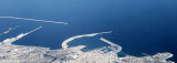
Between the coast and Asinara island, is Piana island, tha divides the pass into two distinct channels: Fornelli pass and Pelosa pass. The easier of the two is that of Fornelli, even if it is very dangerous in rough sea and during the night.
Local meteorology: the prevailing winds are from NW. Those of NE are uncommon, but they raise a heavy sea.
The clouds covering the Scomunica peak, in the N of island Asinara, announce strong winds from the W part.
 Le golfe d'Asinara s'ouvre entre la pointe Caprara, extrémité N de l'île Asinara, et la pointe Tramontana. Son côté W est formé par l'île Asinara. Sa côte S est basse et marécageuse par endroits.
Au S de la pointe Negra le port de Stintino offre un abri sûr.
Entre l'île Asinara et la côte de la Sardaigne se trouve l'île Piana qui divise le passage en deux canaux: le passage des Fornelli et celui de la Pelosa. Le plus facile des deux est celui des Fornelli, même si il est dangereux par mer agitée et pendant la nuit.
Météorologie locale: les vents dominants sont ceux de NW. Ceux de NE sont peu fréquents, mais ils soulèvent une grosse mer. Il Golfo dell'Asinara si apre tra la punta di Caprara, N-terminale della dell'Asinara e la punta Tramontana. Nel frattempo W è costituito dall'Asinara. Il suo lato S è luoghi basso e paludoso in alcuni punti.
S punta Negra il porto di Stintino offre uno buono riparo.
Tra la costa e l'Isola Asinara, si trova l'Isola Piana, la quale divide il passaggio in due canali distinti: passaggio dei Fornelli e passaggio della Pelosa. Dei due il più agevole è quello dei Fornelli, anche se risulta molto pericoloso con mare mosso e durante la notte.
Meteorologia locale: i venti sono prevalenti da NW. Quelli di NE sono rari, ma si rivelano un mare pesante.
Le nuvole che coprono il picco Scomunica, nel N dell'isola Asinara annunciano venti forti da parte W.
Ebook | Sardegna North West
|