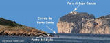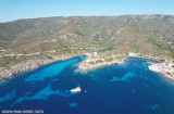


Area Marina Protetta di Capo Caccia - I. Piana (Sardegna)
17nm
212°
20 Nov 12
Joëlle
| Latitude | Longitude | |
| DMS | --- | --- |
| DM | --- | --- |
| DD | --- | --- |
 good holding
 good holding
 12, 16, 74


 Located on a promontory on the north coast of Sardinia, overlooking the Gulf of Porto Torres this great commercial port in the Gulf, is a major port, that connects with a line of summer, Sardinia to the mainland French.
Holiday spot since Roman times already, the city has an extraordinary variety of attractions, but beyond the extraordinary beauty, a gift of nature and history, Porto Torres has another advantage: a strategic geographical position in which is an attractive route.
Porto Torres ferry or by private operators (charter sailing, fishing, tourism, etc..), You can immerse yourself in a beautiful island where nature has been preserved by its isolation, which lasted more a century, and who has a unique heritage of inestimable value.
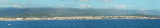
Porto Torres is located at the bottom of Asinara gulf.
Porto Torres includes 2 areas: the industrial port, prohibits to the yachtingl and commercial port includes 1 forward port and 3 docks, port internal dock, the internal dock and new dock where some pontoons are installed.
The entrance is wide about 180 m (oriented NE with depths of 7/8 m) and enters in the outer harbor. The crafts continued to inner quay and new quay where they can moor to the floating pontoons. Give priority to the ferries.
 Situé sur un promontoire sur la côte nord de la Sardaigne, surplombant le golfe de Porto Torres ce grand port de commerce, au fond du golfe, est l'un des principaux ports qui relie, avec une ligne d'été, la Sardaigne au continent français.
 Lieu de vacances déjà depuis les Romains, la ville présente une extraordinaire variété d'attractions, mais au-delà de la beauté extraordinaire, un cadeau de la nature et l'histoire, Porto Torres a un autre avantage: une position géographique stratégique qui en fait un itinéraire attrayant.
De Porto Torres, en ferry ou par des opérateurs privés (Voile charte, la pêche, le tourisme, etc.), Vous pourrez vous immerger dans une île de rêve où la nature a été conservée grâce à son isolement, qui a duré plus d'un siècle, et qui en a fait un patrimoine unique d'une valeur inestimable.
Porto Torres se trouve au fond du golfe d'Asinara.
Porto Torres comprend 2 zones: le port industriel, interdit à la plaisance, et le port commerciale qui comprend 1 avant port et 3 quais, le quai du port interne, le quai interne et le nouveau quai où sont installés quelques pontons.
L'entrée est large d'environ 180 m (orientée vers le NE avec une profondeur de 8,7 m) et conduit à l'avant port. Les plaisanciers se dirigent vers le quai intérieur et le nouveau quai où l'amarrage se fait sur les pontons flottants. Attention, il faut donner la priorité aux Ferries.
 Situato su un promontorio calcareo nella costa nord della Sardegna,
elegantemente affacciata sul Golfo dell’Asinara, Porto Torres è uno dei
principali porti che collegano la Sardegna con il continente e, con una
linea estiva, alla Francia.
Situato su un promontorio calcareo nella costa nord della Sardegna,
elegantemente affacciata sul Golfo dell’Asinara, Porto Torres è uno dei
principali porti che collegano la Sardegna con il continente e, con una
linea estiva, alla Francia.Il porto commerciale di Porto Torres si trova in fondo del golfo di Asinara.
Porto Torres comprende 2 aree: il porto industriale, vieta al diporto e il porto commerciale che comprende 1 avanporto e 3 darsene, la darsena del porto interno, la darsena interna e la darsena nuova dove sono installati alcuni pontili.
L'imboccatura è larga 180 m circa (orientata per NE con fondali di 7/8 m) e immette nell'avamporto. Le unità da diporto proseguono per la darsena interna e nuova dove è possibile l'ormeggio ai pontili galleggianti. Dare precedenza alle navi traghetto.
")
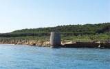
") Poto Torres lighthouse
Poto Torres lighthouse")
")
")
Ebook | Sardegna North West
|
Ebook | Sardegna
|