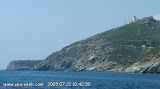
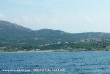
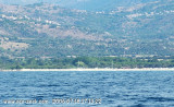
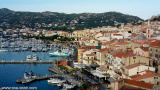
Small private marina sheltered, especially Libeccio and Tramontana. It is located between Calvi and Ile Rousse.
200 berths equipped with chains (not wet)
Draught 1m to 2.5 m
Harbourmaster: Tel. 95 60 70 88
Very difficult access in bad weather in NE 7-8 (entrance near the beach).
The approach must be done by the BN as the edge of the tip are not Dant Ambroggio francs.
The chenal is constantly ensablant, dredging is required annually to maintain the channel about 30m wide and bordered by red buoys.
2012/05/10
Update
Jojo
2012-05-10
Update
Jojo
Petit port de plaisance privé bien abrité, en particulier du Libeccio et de la Tramontane. Il est situé entre Calvi et l'île Rousse.
200 places à quai équipées de chaines (ne pas mouiller)
Tirant d'eau 1m à 2,5m
Capitainerie: Tél. 95 60 70 88
Accès très difficile par mauvais temps de NE 7 à 8 (entrée proche de la plage).
L'approche doit se faire par le NE car les abords de la pointe Dant Ambroggio ne sont pas francs.
La passe s'ensablant constamment, un dragage est nécessaire chaque année pour maintenir le chenal large d'environ 30m et délimité par des bouées rouges.
The nature reserve, which is part of the Regional Natural Park of Corsica, occupies the Scandola peninsula, an impressive, porphyritic rock mass. The vegetation is an outstanding example of scrubland. Seagulls, cormorants and sea eagles can be found there. The clear waters, with their ...
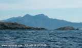
Capo Sagro is located at 11 NM. S Finocchiarola islands. He has a signal station and a semaphore rises N of it. Mount Merizatodio, 778 m high, is 1.5 MN to W Cape and dominates the immediate area.
The village of Erbalunga, situated 1.5 miles SSW of Capo Sagro, stands on the S ...
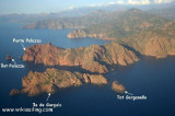
On the other side of the Gulf of Calvi is a beautiful site that transports us in an unforgettable setting. Point of Spano (natural site), where small coves framed by the rocks offer a splendid view over the Bay of Calvi.
Spanu island is an island inhabited only by seagulls, ...
The small port, San Damianu, housed a Roman port dropped from 500 to 600 BC to the twelfth century, after date will be built a defensive tower. It is possible to anchor in the cove formed by the pier which can accommodate only small boats. The surf is unpleasant by westerly wind.
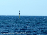
At 1.3 miles in 24 ° of the tip of Sant Ambroggio, a little rock, totally insulated, covered with one meter of water, is marked by a buoy north light. It can be hard to spot against the light. But generally in the day the presence of small fishing boats reported this shoal that ...
Algajola was a position Genoese advanced in front of Calvi. The 1st houses correspond to the sites prehistoric and protohistoric of Tepina-Cocani and to the site of Mount St. Joseph.
The site is very picturesque but you must anchor at a distance and without any protection.


 A l'entrée du bassin W
 25 T
25 T


 Small private marina sheltered, especially Libeccio and Tramontana. It is located between Calvi and Ile Rousse.
 Petit port de plaisance privé bien abrité, en particulier du Libeccio et de la Tramontane. Il est situé entre Calvi et l'île Rousse.