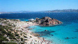
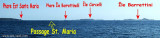
Mezzo Schifo or Sciulara bay lies between Sardegna tip and Palau tip.
It is sheltered from SW / NW winds.
Good anchorage in 0.4 NM to W Palau Lighthouse.
The harbor, also known as Nelson Bay, because, in 1803, it housed the fleet of Admiral Englishman, who gave his name "Schifo" from the dialect of the Maddalena meaning "boat", "shell".
2012/11/23
Update
Joëlle
La rade de Mezzo Schifo ou de la Sciulara se trouve entre la pointe Sardegna et celle de Palau.
Elle est abritée des vents du SW/NW.
Bon mouillage à 0,4 M à l'W du phare de la pointe Palau.
La rade, appelée aussi Baie de Nelson parce-que, en 1803, elle abrita la flotte de l'Amiral Anglais, ce qui donna son nom "Schifo" issu du dialecte de la Maddalena qui signifiait "bateau", "coque".
2012/09/6
Update
Joëlle
La rada di Mezzo Schifo o della Sciumaracollega la Punta Sardegna con Palau.
E' riparata dei venti del SW/NW.
Buon ancoraggio a mezzo miglio circa W dal fanale di Punta Palau.
La rada, chiamata anche Baia di Nelson perché nel 1803 ospitò la flotta
dell’ammiraglio inglese, deve il suo nome al termine "schifo" del
dialetto maddalenino che significa "barca", "scafo".
It is the largest island of the archipelago composed of sixty islets and 7 major islands, in the NE end tip of Sardinia. It is mountainous and arid. This is the only inhabited island thoroughly. It is connected by a bridge to Caprera island where are the house and the tomb of Garibaldi. ...
Gulf of Arzachena (Arsachena), located between Punta Saline and Tre Monti Cape, is a high inlet whose banks are lined with shoals. S tip, Arzachena, W of the entrance, a beacon consists of an iron post with a sheer spherical white marks a rock particularly ...
La tourelle Pecorella marque l'entrée de ce golfe qui s'enfonce à plus de 4 M dans les terres. Celle de Chiapino qui était plus au S est démolie. Il faut donc remonter suffisamment vers le N pour ne pas risquer d'en toucher les restes. En piquant vers l'W, la balise noire délimite ...
SW of Corsica offers some of the most beautiful anchorages. As you get closer to Bonifacio be carreful with the weather forecast as the NW wind can be very strong.
The range of the tide in this area is negligible. There are no regular currents along the coasts of Corse, ...


")
")
 Mezzo Schifo or Sciulara bay lies between Sardegna tip and Palau tip.
 La rade de Mezzo Schifo ou de la Sciulara se trouve entre la pointe Sardegna et celle de Palau.
 La rada di Mezzo Schifo o della Sciumara collega la Punta Sardegna con Palau.
")