Punta Vignola (Punta di Francesi Portobello Sardegna)
Latitude
Longitude
DMS
---
---
DM
---
---
DD
---
---
Characteristics
Description
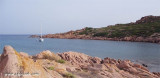
Punta di Li Francesi or Punta Vignola, is 11 NM NE of Isola Rossa. It is 28 m high and rocky. A tower in ruins stands 0,5 NM of this point.
A shoal, with a depth of 9,4 m, lies about 1,5 NM ENE of the tower.
2012/11/22
Update
Joëlle
Punta di Li Francesi ou Punta Vignola, est à 11 MN au NE de Isola Rossa. Elle est haute de 28 m et rocheuse. Une tour en ruine s'élève à 0,5 MN au SE de ce point.
Un haut-fond à 9,4 m de profondeur se trouve à 1,5 MN à l'ENE de la tour.
2012/11/22
Update
Joëlle
Punta di Li Francesi o Punta Vignola, si trova a 11 MN a NE da Isola Rossa. E' 28 m alta e rocciosa. Una torre in rovina si erge a 0,5 MN a SE da questa punta.
Una secca a 9,4 m di fondali si trova a 1,5 MN a ENE dalla torre.
SW of Corsica offers some of the most beautiful anchorages. As you get closer to Bonifacio be carreful with the weather forecast as the NW wind can be very strong.
The range of the tide in this area is negligible. There are no regular currents along the coasts of Corse, ...
It is the largest island of the archipelago composed of sixty islets and 7 major islands, in the NE end tip of Sardinia. It is mountainous and arid. This is the only inhabited island thoroughly. It is connected by a bridge to Caprera island where are the house and the tomb of Garibaldi. ...
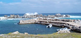
Small port in a natural cove, for small boats. It is frequented mainly by the club owners of adjacent towns.Dangers: reefs in the immediate vicinity of the landing. Depth: 0.50 to 1.50 m T. Club: (079) 65 67 66 Maximum length: 5 m
Gulf of Arzachena (Arsachena), located between Punta Saline and Tre Monti Cape, is a high inlet whose banks are lined with shoals. S tip, Arzachena, W of the entrance, a beacon consists of an iron post with a sheer spherical white marks a rock particularly ...
La tourelle Pecorella marque l'entrée de ce golfe qui s'enfonce à plus de 4 M dans les terres. Celle de Chiapino qui était plus au S est démolie. Il faut donc remonter suffisamment vers le N pour ne pas risquer d'en toucher les restes. En piquant vers l'W, la balise noire délimite ...


 Punta di Li Francesi or Punta Vignola, is 11 NM NE of Isola Rossa. It is 28 m high and rocky.
 Punta di Li Francesi ou Punta Vignola, est à 11 MN au NE de Isola Rossa. Elle est haute de 28 m et rocheuse.
 Punta di Li Francesi o Punta Vignola, si trova a 11 MN a NE da Isola Rossa. E' 28 m alta e rocciosa.
")
")
")
")