SW of Corsica offers some of the most beautiful anchorages. As you get closer to Bonifacio be carreful with the weather forecast as the NW wind can be very strong.
The range of the tide in this area is negligible. There are no regular currents along the coasts of Corse, ...
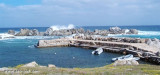
Small port in a natural cove, for small boats. It is frequented mainly by the club owners of adjacent towns.Dangers: reefs in the immediate vicinity of the landing. Depth: 0.50 to 1.50 m T. Club: (079) 65 67 66 Maximum length: 5 m
It is the largest island of the archipelago composed of sixty islets and 7 major islands, in the NE end tip of Sardinia. It is mountainous and arid. This is the only inhabited island thoroughly. It is connected by a bridge to Caprera island where are the house and the tomb of Garibaldi. ...
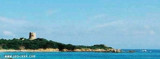
Punta di Li Francesi or Punta Vignola, is 11 NM NE of Isola Rossa. It is 28 m high and rocky. A tower in ruins stands 0,5 NM of this point.A shoal, with a depth of 9,4 m, lies about 1,5 NM ENE of the tower.
Gulf of Arzachena (Arsachena), located between Punta Saline and Tre Monti Cape, is a high inlet whose banks are lined with shoals. S tip, Arzachena, W of the entrance, a beacon consists of an iron post with a sheer spherical white marks a rock particularly ...


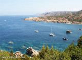
 Small natural and wild indentation, it is surrounded by red rocks and deserves to be visited.
 Petite anse naturelle et sauvage, elle est entourée de roches rouges et mérite d'être visitée.
 Piccola insenatura naturale e selvaggia, è circondata di roccie rosse e merita una visita.
")
")
")