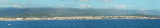
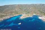
Punta Tramontana is the E end of Asinara gulf. The coast between this point and Porto Torres is moderately high and steep, with a succession of sand dunes in the E part.
2012/11/22
Update
Joëlle
Punta Tramontana est l'extrémité E du golfe d'Asinara. La côte entre ce point et Porto Torres est modérément haute et raide, avec une succession de dunes de sable dans la partie E.
2012/11/22
Update
Joëlle
Punta Tramontana è la fine E del Golfo dell'Asinara. La costa tra questa punta e Porto Torres è moderatamente alta e ripida, con un susseguirsi di dune di sabbia nella parte E.
SW of Corsica offers some of the most beautiful anchorages. As you get closer to Bonifacio be carreful with the weather forecast as the NW wind can be very strong.
The range of the tide in this area is negligible. There are no regular currents along the coasts of Corse, ...
The park begins at Capo Galera to continue toward the gulf of Porto Conte that is protected by two promontories, Punta Giglio and Capo Caccia-Monte Timidone. The marine protected area embraces the stretch of sea to the north-west of Punta Cristallo.Almost all of the park consists ...
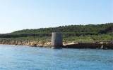
The harbor is located at W from Castelsardo that stands on a small promontory, 4 NM NE of Punta Tramontana.Beware: by N-NW winds, a big swell is formed at mouth of the harbor. Secca di Castelsardo (11 m depth) is 5,5 NM N harbour. Secca di Punta Spinosa, (9 m depth) lies about ...
Rada di Alghero is entered between S, the town of Alghero and N, capo Galera.The E shore of this bay is low and sandy, and the W shore is hilly and rocky. An undulating coastal plain, partly under cultivation, lies immediately inland of the head of this bay.This bay is open to ...
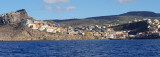
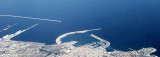
Located on a promontory on the north coast of Sardinia, overlooking the Gulf of Porto Torres this great commercial port in the Gulf, is a major port, that connects with a line of summer, Sardinia to the mainland French. Holiday spot since Roman times already, the city has an extraordinary ...


 Punta Tramontana is the E end of Asinara gulf.
 Punta Tramontana est l'extrémité E du golfe d'Asinara.
 Punta Tramontana è la fine E del Golfo dell'Asinara.
")
")