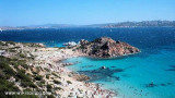
Punta Sardegna is one of the fragments of land that is located on the sea in front of the magnificent archipelago of La Maddalena. The white lighthouse was built in 1913. S of tip the coast is rocky and steep with few small beaches. An area of submarine cables in which anchor and fishing are prohibited lies between the coast and the island of La Maddalena. This area includes the W part of Mezzo Schifo bay.
2012/11/25
Update
Joëlle
Punta Sardegna est un des lambeaux de terre qui se trouve sur la mer devant le majestueux archipel de la Maddalena. Le phare blanc a été édifié en 1913. Au S de la pointe la côte est rocheuse et abrupte avec quelques petites plages. Une zone de cables sous-marins dans laquelle le mouillage et la pêche sont interdits s'étend entre la côte et l'île de la Maddalena. Cette zone englobe la partie W de la rade de Mezzo Schifo.
2012/11/25
Update
Joëlle
Punta Sardegna è uno dei lembi di terra che si trova sulla mare davanti al maestoso Arcipelago della Maddalena. Il faro biancho è stato edificato nel 1913. Punta S della costa è rocciosa e ripida con alcune spiagge di piccole dimensioni. Un'area di cavi sottomarini in cui sono vietate l'ancoraggio e la pesca si trova tra la costa e l'isola della Maddalena. Quest'area comprende la parte W della rada di Mezzo Schifo.
It is the largest island of the archipelago composed of sixty islets and 7 major islands, in the NE end tip of Sardinia. It is mountainous and arid. This is the only inhabited island thoroughly. It is connected by a bridge to Caprera island where are the house and the tomb of Garibaldi. ...
Gulf of Arzachena (Arsachena), located between Punta Saline and Tre Monti Cape, is a high inlet whose banks are lined with shoals. S tip, Arzachena, W of the entrance, a beacon consists of an iron post with a sheer spherical white marks a rock particularly ...
La tourelle Pecorella marque l'entrée de ce golfe qui s'enfonce à plus de 4 M dans les terres. Celle de Chiapino qui était plus au S est démolie. Il faut donc remonter suffisamment vers le N pour ne pas risquer d'en toucher les restes. En piquant vers l'W, la balise noire délimite ...
SW of Corsica offers some of the most beautiful anchorages. As you get closer to Bonifacio be carreful with the weather forecast as the NW wind can be very strong.
The range of the tide in this area is negligible. There are no regular currents along the coasts of Corse, ...


 Punta Sardegna is one of the fragments of land that is located on the sea in front of the magnificent archipelago of La Maddalena.
  Punta Sardegna est un des lambeaux de terre qui se trouve sur la mer devant le majestueux archipel de la Maddalena.
 Punta Sardegna è uno dei lembi di terra che si trova sulla mare davanti al maestoso Arcipelago della Maddalena.

 Punta Sardegna from the East