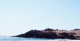
It is the S tip of Bahia Inglese ( Bahia Inglese is of no use to navigation, it is exposed to N winds).
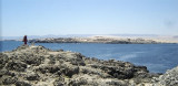
Punta Morro is rocky and steep. It is the N end of a chain of mountains which extends SE from the point. Morro Copiapo lies about 1 NM S of Punta Morro.
2013/01/8
Update
Joëlle
C'est la pointe S de Bahia Inglese (baie qui n'est pas recommandée à la navigation car exposée aux vents du N).
Punta Morro est rocheuse et élevée. C'est l'extrémité N d'une chaîne de montagnes qui s'étend au SE de la pointe. Morro Copiapo se trouve à environ 1 MN au S de Punta Morro.
Bahia Copiapo lies S Punta Vial up to punta Dallas, even more in S. It is bordered to the center by a sandy beach and by rocks at each end. Copiapo was once a shipping ore port, but it is no longer used such as such because of the poor anchorage and landing ...
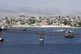
Bahia Caldera is located between Punta Francisco and Punta Caldera. Caldera town is S Caldera harbour, SE of the bay.The bay is protected from SW winds. Strong N winds sometimes send a heavy swell into Puerto Caldera, particularly in the S part of the harbor. The port is situated ...
Caleta Calderilla is about 2 NM S Punta Caldera lighthouse, between Punta Zorro and Punta Caldereta.
Rocks wich extend up to 0,1 NM from each of these points narrow the entrance of the cove to about 0,3 NM.A beacon is situated on Punta Zorro and a light is shown from Punta ...
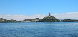
Punta Caldera is the S point of puerto Caldera. The point is low, it is the W end of a small peninsula. A light is shown from Punta Caldera.Islote Centinela Blanco and Islote Centinela Negro are islets which stand on a reef extending up to 0.3 mile W of the point.


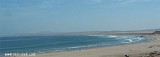


 It is the S tip of Bahia Inglese ( Bahia Inglese is of no use to navigation, it is exposed to N winds).
 C'est la pointe S de Bahia Inglese (baie qui n'est pas recommandée à la navigation car exposée aux vents du N).
")