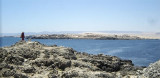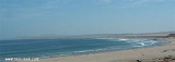

Bahia de Copiapo (Atacama N Chile)
17nm
201°
Copiapo was once a shipping ore port, but it is no longer used such as such because of the poor anchorage and landing ...
9 Jan 13
Joëlle
| Latitude | Longitude | |
| DMS | --- | --- |
| DM | --- | --- |
| DD | --- | --- |

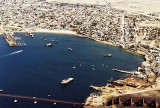
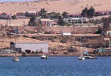
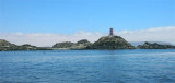
 Bahia Caldera is located between Punta Francisco and Punta Caldera. Caldera town is S Caldera harbour, SE of the bay.
The bay is protected from SW winds. Strong N winds sometimes send a heavy swell into Puerto Caldera, particularly in the S part of the harbor. The port is situated at the N limit of these winds; they are seldom of sufficient force to interrupt work here.
The climate is very mild and there is no rain. Fogs are infrequent, and usually disappear by noon.
The mean spring tidal rise here is 1m, while the mean neap range is 0.6m. Strong currents setting S into Puerto Caldera occur when there are strong N winds. A strong current was reported setting NE across the entrance of the bay.
")
 Bahia Caldera est située entre Punta Francisco et Punta Caldera. La ville de Caldera se trouve au S du port Caldera, au SE de la baie.
La baie est protégée des vents du SW. Les forts vents du N provoquent quelquefois de la forte houle dans le port, particulièrement dans la partie S du port.Le port est situé à la limite N de ces vents qui sont rarement suffisamment forts pour interrompre le travail.
Le climat est très doux et il n'y a pas de pluie. Les brouillards ne sont pas fréquents et disparaissent généralement avant midi.
La hausse moyenne des marées de printemps ici est de 1m, tandis que la moyenne des basses-eaux est de 0,6 m. Les forts courants de S dans Puerto Caldera se produisent quand il y a de forts vents du N. Un fort courant de NE a été signalé à l'entrée de la baie.
")
Ebook | Chile
|