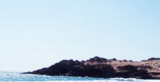

Punta Copiapo (Atacama N Chile)
0.8nm
161°
10 Jan 13
Joëlle
| Latitude | Longitude | |
| DMS | --- | --- |
| DM | --- | --- |
| DD | --- | --- |

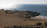
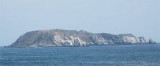
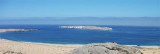
 Bahia Copiapo lies S Punta Vial up to punta Dallas, even more in S. It is bordered to the center by a sandy beach and by rocks at each end.
Copiapo was once a shipping ore port, but it is no longer used such as such because of the poor anchorage and landing facilities.
A group of reefs (Caja Grande), with about 4 m depth, fronts the bay.
The anchorage in the bay is unprotected and generally bad. It is prudent to give a long scope of chain and to drop another anchor.
N bay we found generally about 9 m depth. Landing on any part of the shore of the bay is difficult and dangerous.
")
 Bahia Copiapo s'étend au S de Punta Vial jusqu'à punta Dallas, encore plus au S. Elle est bordée au centre par une plage de sable et des rochers à chacune de ses extrémités.
Copiapo était autrefois un port d'expédition du minerai, mais il n'est plus utilisé en tant qu tel en raison de la mauvaise qualité du mouillage et des services au débarquement.
Un groupe de récifs (Caja Grande), avec 4 m de fond environ, fait face à la baie.
Le mouillage dans la baie n'est pas protégé et généralement mauvais. Il est prudent de laisser beaucoup de chaîne et de mouiller sur deux ancres.
Au N de la baie on trouve en général environ 9 m de fond. Mouiller sur n'importe quelle partie près de la rive est difficile et dangereux.
Ebook | Chile
|