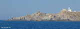
Punta Falcone (57 m high), of Santa Teresa di Gallura municipality, is situated opposite Cape Pertusato (Corsica). It has been known since ancient times for its granite quarries exploited in Roman times. This is the most N of Sardinia.
2012/11/23
Update
Joëlle
Punta Falcone (57 m de haut), de la commune de Santa Teresa di Gallura, se trouve en face du cap Pertusato (en Corse). Il connu depuis l'Antiquité pour ses carrières de granite exploitées à l'époque romaine. C'est le point le plus au N de la Sardaigne.
2012/11/23
Update
Joëlle
Punta Falcone (57 m alta), del comune di Santa Teresa di Gallura, si trova davanti a capo Pertusato (in Corsica). E' conosciuto sin dall’antichità per le cave di granito sfruttate in epoca romana. Rappresenta il punto più settentrionale in assoluto della Sardegna.
SW of Corsica offers some of the most beautiful anchorages. As you get closer to Bonifacio be carreful with the weather forecast as the NW wind can be very strong.
The range of the tide in this area is negligible. There are no regular currents along the coasts of Corse, ...
It is the largest island of the archipelago composed of sixty islets and 7 major islands, in the NE end tip of Sardinia. It is mountainous and arid. This is the only inhabited island thoroughly. It is connected by a bridge to Caprera island where are the house and the tomb of Garibaldi. ...
La tourelle Pecorella marque l'entrée de ce golfe qui s'enfonce à plus de 4 M dans les terres. Celle de Chiapino qui était plus au S est démolie. Il faut donc remonter suffisamment vers le N pour ne pas risquer d'en toucher les restes. En piquant vers l'W, la balise noire délimite ...
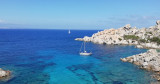
Cape Testa the northernmost part of Sardinia. It directly overlooks the Strait of Bonifacio, Corsica. Cape Testa is a characteristic cluster of rocks, gathered at the coast by a narrow isthmus of sand and drawing down the two beautiful bays of Santa Reparata and Colba. Along the ...
Narrow cove bordered by a small sandy beach which is sometimes frequented by campers and hikers. The cove is beautiful and calm. We anchored in 10m on a sandy bottom, excellent.
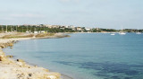
Reparata bay is a good shelter in N Cape Testa, protecting it from winds from the south or west.
At the entrance, beware at the shoals on the NW side.The best anchorage lies about 200 m from the E shore.


 Punta Falcone (57 m high), of Santa Teresa di Gallura municipality, is situated opposite Cape Pertusato (Corsica).
 Punta Falcone (57 m de haut), de la commune de Santa Teresa di Gallura, se trouve en face du cap Pertusato (en Corse).
 Punta Falcone (57 m alta), del comune di Santa Teresa di Gallura, si trova davanti a capo Pertusato (in Corsica).
")