Senetose - Tizzano
23nm
319°
The range of the tide in this area is negligible. There are no regular currents along the coasts of Corse, ...
15 May 12
dd
| Latitude | Longitude | |
| DMS | --- | --- |
| DM | --- | --- |
| DD | --- | --- |

") Près du phare on voit la maison basse à corps cylindrique de l'ancien sémaphore. Un petit pilier qui se dresse sur le sommet du promontoire (127 m) n'est visible qu'à une distance de quelques Milles
Près du phare on voit la maison basse à corps cylindrique de l'ancien sémaphore. Un petit pilier qui se dresse sur le sommet du promontoire (127 m) n'est visible qu'à une distance de quelques Milles")
")
Ebook | Sardegna North East
|
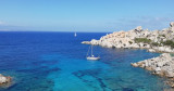
 Cape Testa the northernmost part of Sardinia. It directly overlooks the Strait of Bonifacio, Corsica.
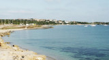
Cape Testa is a characteristic cluster of rocks, gathered at the coast by a narrow isthmus of sand and drawing down the two beautiful bays of Santa Reparata and Colba. Along the peninsula is a succession of granite rocks, sometimes of fantastic shapes, and small sandy coves.
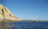
A light, white house (33 m high) with a floor from which rises a square tower white, stands near the NW end of the peninsula. Cape Testa is overwhelmed by rocks and boulders.
Isolated shoals, covered by 6.5 to 10 m of water, extend to 1.3 M in W. The sea breaks in bad weather.
Between Capo Testa and Punta Falcone, 3.5 miles E, the S side of the Strait of Bonifacio is high, rocky, and fringed with rocks and shoals.
 Le Cap Testa est le cap le plus au nord de la Sardaigne. Il donne directement sur le détroit de Bonifacio, en Corse.
Le cap Testa est un amas caractéristique de rochers, réunis à la côte par un isthme de sable étroit et bas dessinant les deux belles baies de Santa Reparata et de la Colba. Le long de la presqu'île se succèdent des rochers de granit, parfois de formes fantastiques, et de petites criques sableuses.
Il porte un phare (33 m de haut), maison blanche à un étage d'où s'élève une tour carrée blanche, qui s'élève près de l'extrémité NW de la péninsule. Le cap Testa est débordé par des roches et des rochers.
Des hauts-fonds isolés, couverts de 6,5 à 10 m, s'étendent jusqu'à 1,3 M à l'W.La mer y brise par mauvais temps.
Entre Capo Testa et Punta Falcone, à 3,5 MN à l'E, le côté S du détroit de Bonnifacio est haut, rocheux et parsemé de rochers et de hauts-fonds.
 Capo Testa è la parte più settentrionale della Sardegna. Si affaccia direttamente sullo stretto di Bonifacio, Corsica.
Indossa una luce (33 m alta), la casa bianca con un pavimento dal quale si erge una torre quadrata bianca, vicino all'estremita NW della peninsola. Capo Testa è sopraffatto da rocce e massi.
Tra Capo Testa e Punta Falcone, a 3,5 MN all'E, il lato S dello detroit di Bonifacio è alto, roccioso e puntegiato di roccia e di banchi.
Ebook | Sardegna
|
")