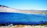
Bahia Copiapo lies S Punta Vial up to punta Dallas, even more in S. It is bordered to the center by a sandy beach and by rocks at each end. Copiapo was once a shipping ore port, but it is no longer used such as such because of the poor anchorage and landing ...
At the head of the cove there are sandy slopes with outcrops of rocks.We can anchor about 0,5 NM ENE of Punta Bell, in 18 to 21 m.The cove is protected from SW winds bu it is exposed to N winds and it is not advisable to anchor here during such times.There is a small iron pier on ...
This cove is about 4 NM S of Punta Cachos.Shoals water extends from the head of Caleta Pajonal shore where two small above water rocks close NW of them. Dangerous submerged rocks lie about 0,8 NM SW of the same point. The sea breaks over these rocks and there is a heavy swell.We ...
Punta Salado, at about 4 NM S of Punta Barranquillas, is rocky and steep.A group of islets extends up to 0,8 NM SW from the point. The largest is named Isla Ruky. The coast, for 3 NM S of Isla Ruky, is foul, and there are depths of 8,9 m and 11 m, about 2,5 NM SW of the islet.


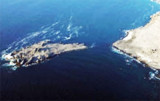
 Punta Cahos is the SW entrance point of Bahia Salado. It has an islet and some rocks off its W side.
 Punta Cachos est l'entrée SW de Bahia Salado. Elle est débordée par un îlot et quelques rochers sur son côté W.
")
")