Caleta del Medio (Atacama N Chile)

Caleta del Medio (Atacama N Chile)

To precisely geolocate this site. Update if necessary.

Localisation

Caleta del Medio (Atacama N Chile)
LatitudeLongitude
DMS------
DM------
DD------

Characteristics

Mooring
Sand
Beach
Sand

Description

At the head of the cove there are sandy slopes with outcrops of rocks.

We can anchor about 0,5 NM ENE of Punta Bell, in 18 to 21 m.

The cove is protected from SW winds bu it is exposed to N winds and it is not advisable to anchor here during such times.

There is a small iron pier on the N side of Punta Slade, on the W side of Caleta del Medio.

2013/01/11
Update
Joëlle
Au fond de Caleta del Medio il y a des bancs de sable avec quelques roches affleurantes.

On peut mouiller à environ 0,5 MN à l'ENE de Punta Bell, par 18 à 21 m.

L'anse est protégée des vents du SW mais elle est exposée aux vents du N et il n'est pas recommandé d'ancrer son bateau pendant ces périodes.

Il y a une petite jetée au N de Punta Slade, sur le côté W de l'anse. 

2013/01/11
Update
Joëlle
Caleta del Medio (Atacama N Chile)
2013-01-11
Update
Joëlle
Ebook

Chile

  • 118 sites
  • 166 photos
  • publication date: 6 Jul 2023
  • .pdf file size: 34 Mb
Share your comments or photos on "Caleta del Medio (Atacama N Chile)"

Sites around Caleta del Medio (Atacama N Chile)

Flying distances - Direct line

Bahia de Copiapo (Atacama N Chile)

21nm
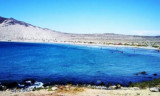
Bahia Copiapo lies S Punta Vial up to punta Dallas, even more in S. It is bordered to the center by a sandy beach and by rocks at each end.
Copiapo was once a shipping ore port, but it is no longer used such as such because of the poor anchorage and landing ...
9 Jan 13
Joëlle

Punta Cachos (Atacama N Chile)

1.7nm
296°
Punta Cahos is the SW entrance point of Bahia Salado. It has an islet and some rocks off its W side.
14 Jan 13
Joëlle

Caleta Pajonal (Atacama N Chile)

3.7nm
212°
This cove is about 4 NM S of Punta Cachos.Shoals water extends from the head of Caleta Pajonal  shore where two small above water rocks close NW of them.
Dangerous submerged rocks lie about 0,8 NM SW of the same point. The sea breaks over these rocks and there is a heavy swell.We ...
14 Jan 13
Joëlle

Punta Salado (Atacama N Chile)

7.2nm
44°
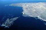
Punta Salado, at about 4 NM S of Punta Barranquillas, is rocky and steep.A group of islets extends up to 0,8 NM SW from the point. The largest is named Isla Ruky. The coast, for 3 NM S of Isla Ruky, is foul, and there are depths of 8,9 m and 11 m, about 2,5 NM SW of the islet.
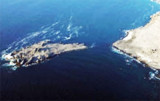
10 Jan 13
Joëlle