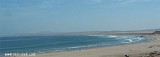
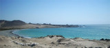
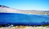
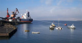
Puerto Carrizal Bajo is near Isla Carrizal. It is well sheltered from prevailing winds by this islet. During N winds a rough sea enters the port. Fogs occur usually only during the winter season.
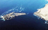
Puerto Carrizal Bajo is a small port for the shipment of iron ore. The port is little used because of the lack of trade. An old wharf, of rails and slag, has a depth of 2.4m alongside and can be used as a landing. A government-owned fisherman’s wharf was built in 1998 immediately to the NE of Escoria Point. The wharf has a length of 57m and a width of 7m. The depth alongside is 3m.
2013/02/6
Update
Joëlle
2013-02-06
Update
Joëlle
Puerto Carrizal Bajo se trouve près de Isla Carrizal. Il est bien protégé du vent dominant par cette îlot. Quand souffle le vent du N une forte mer entre dans le port. Le brouillard paraît généralement seulement pendant la saison d'hiver.
Puerto Carrizal Bajo est un petit port pour l'expédition de minerai de fer. Le port est peu utilisé en raison de l'absence de commerce. Un ancien quai, avec une profondeur de 2,4 m peut être utilisé pour accoster. Un quai de pêcheurs appartenant au gouvernement a été construit en 1998 juste au NE de la Pointe Escoria. Le quai a une longueur de 57 m et une largeur de 7 m. La profondeur est de 3m.
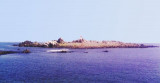
Isla Carrizal is starboard, entering Puerto Carrizal Bajo, on the tip Escoria. It is almost round and is about 6 m high.The island and the tip Escoria are connected by an isthmus of sand, shingle and mining waste. An islet, fringed by reefs, lies about 0.1 NM W of Escoria tip.
Bahia Copiapo lies S Punta Vial up to punta Dallas, even more in S. It is bordered to the center by a sandy beach and by rocks at each end. Copiapo was once a shipping ore port, but it is no longer used such as such because of the poor anchorage and landing ...
Caleta Matamoros, about 2,5 NM S punta Totoral, is well sheltered from S winds, but is open to N winds.We can anchor S cove, in 13 to 18 m. It is not recommanded to anchor near the shore in 13 m because the bottom is rocky. N winds send a heavy swell throughout the cove.
This cove is about 4 NM S of Punta Cachos.Shoals water extends from the head of Caleta Pajonal shore where two small above water rocks close NW of them. Dangerous submerged rocks lie about 0,8 NM SW of the same point. The sea breaks over these rocks and there is a heavy swell.We ...
The commercial port Guacolda is closed to the town of Huasco Bajo, at the SE end of Guacolda bay.The port was used between 1851 and 1873 to ship copper ore, copper regulus, alpaca wool and hides round Cape Horn to Swansea, Glamorgan and Wales.
The port is ...


 Puerto Carrizal Bajo is near Isla Carrizal.
")
 Puerto Carrizal Bajo se trouve près de Isla Carrizal.
")