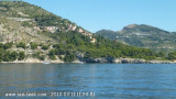
Capo Mortola can be recognized by Villa Hambury, a reddish building surmounted by a prominent square tower on its W side, standing 0.2 mile N of it.
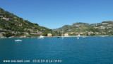
A fresh water spring lies in a depth of 14m, about 300m SSW of the cape. With a calm sea, the boiling action of this spring can be seen on the surface. The spring is marked by a lighted buoy.
2011/07/19
Update
Atoi
Le cap Mortola, au sommet boisé, est débordé sur plus de 300 m par des roches couvertes par endroit d'1 m d'eau. Ces roches sont balisées par une bouée S, il faut s'en écarter d'au moins 300 m.
La grande villa Hambury, à tour carrée (fameuse pour son jardin), se remarque au milieu des arbres.
2011/07/19
Update
Atoi
Capo Mortola, vetta boscosa, è sopraffatto oltre 300 m di rocce coperte di posti da 1 m di acqua. Queste rocce sono caratterizzate da una boa S, dobbiamo deviare almeno 300 m.
La grande villa Hambury, con Torre Quadrata (famosa per il suo giardino), è notevole tra gli alberi.
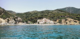
Si puo ancorare sul lato del Capo W, W di Villa Hanbury, da 7 m di profondità, al riparo dai venti di Levante.
Le Cap d'Ail marque la séparation entre les baies de Beaulieu et de Monaco. Les abords étant malsains, il faut s'en écarter assez largement. Le cap Martin est couvert de pins d'où émerge un sémaphore blanc sur les hauteurs.
Mento is a small harbor, lies 2 miles NE of Cap Martin. It is protected by two jetties and is used by fishing boats and yachts. The town stands in an amphitheater which is situated on a small promontory at the NE end of a beach. A square tower stands on the extremity of the promontory, ...
The Presqu'ile de Saint Hospice , 40m high, forms a peninsula which extends E from the center of the E side of the Cap Ferrat promontory. It is surmounted by a chapel and a conspicuous tower Pointe Saint Hospice, located 1.2 miles NE of the Cap Ferrat Light, is the E extremity of ...
Mouillage par 3 à 5 mètres d'eau dans du sable et des herbiers. Aucune protection de la houle. Néanmoins, semble plus accueillant que le mouillage Ouest du Cap Mortolla.


 Cardinale Sud
 Capo Mortola can be recognized by Villa Hambury, a reddish building surmounted by a prominent square tower on its W side, standing 0.2 mile N of it.
 Le cap Mortola, au sommet boisé, est débordé sur plus de 300 m par des roches couvertes par endroit d'1 m d'eau. Ces roches sont balisées par une bouée S, il faut s'en écarter d'au moins 300 m.
 Capo Mortola, vetta boscosa, è sopraffatto oltre 300 m di rocce coperte di posti da 1 m di acqua. Queste rocce sono caratterizzate da una boa S, dobbiamo deviare almeno 300 m.