Miami Beach (Florida)
4nm
28°
The city is ...
8 Apr 10
Joëlle
| Latitude | Longitude | |
| DMS | --- | --- |
| DM | --- | --- |
| DD | --- | --- |


 all berths


")
Ebook | US - East coast
|
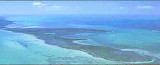
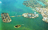
 Miami is a seaport located in Biscayne
Miami, the State?s most populated city, covers most of the west shore of Biscayne Bay north of Key Biscayne and is 5 miles from the Gulf Stream, a fact which accounts for its year-round healthful climate. It is an internationally famous winter resort and a popular yachting center, particularly in winter. A large number of small boats that fish and cruise along the Florida Keys operate out of the port.
The Port of Miami is able to berth the largest passenger vessels with exciting itineraries and on-board entertainment, which make cruising among the best and most economical vacation experiences.
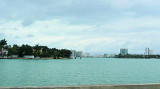
The Port of Miami has over 30 deepwater berths adjacent to the Miami Harbor Channel; these include the berths at the Port of Miami on Dodge Island, and the privately owned facilities on the north side of Fisher Island and just west of Causeway Island.
The facilities at the Port of Miami are owned by the Miami-Dade County Seaport Department.
All berths have fresh water available, but electric power and telephone hookups are not provided. Dodge and Lummus Islands are fully merged, and should be considered a single facility.
A single track bascule bridge allows Florida East Cost Railway to access warehouses A, B, C & G in the cargo area of the Port. A four-track railway marshaling yard is provided in the cargo area.
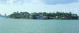
Fisher Island can only be reached by water transportation (shuttle barges).
Small-craft facilities are distributed along the east and west shores of Biscayne Bay from above Baker Haulover Inlet to Dinner Key, on Miami River, and on Tamiami and Miami Canals. Marine railways, lifts, and launching ramps are available.
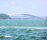
Two unmarked jetties protect the harbor entrance, known as Government Cut, which was dredged to form a deepwater entry to the port.
 Miami est une ville portuaire située dans la baie de Biscayne à Miami, en Floride,
Miami, ville la plus peuplée de l'État, couvre la majorité de la rive ouest de la baie de Biscayne, au nord de Key
Biscayne et est à 5 miles du Gulf Stream, ce qui explique son climat sain toute l'année. Elle offre un hiver doux de renommée internationale et un centre de yachting populaire, surtout en hiver. Un grand nombre de petits bateaux de croisière qui pèchent le poisson le long des Florida
Keys s'abritent au port de Miami.
Le port de Miami offre l'accostage des plus grands navires à passagers avec des itinéraires passionnants et de nombreux divertissements à bord, qui rendent la croisière parmi les meilleures expériences de vacances et les plus économiques.
Le port de Miami a plus de 30 places en eaux profondes à côté du canal
Miami Harbor; Il s'agit notamment des postes d'amarrage dans le port de
Miami, sur Dodge Island, et les installations privées sur le côté nord de Fisher Island et à l'ouest de l'île de Causeway.
Les installations du port de Miami sont la propriété du ministère de Miami-Dade County
Seaport.
Toutes les places ont l'eau douce disponible, mais l'énergie électrique et des branchements téléphoniques ne sont pas fournis. Dodge et les îles Lummus sont entièrement fusionnées, et doivent être considérées comme une seule installation.
Un seul pont à bascule permet de relier les chemins de fer Floride East Cost aux entrepôts d'accès A, B, C & G dans la zone de cargaison du port. Un chemin de fer à quatre voies de triage marshaling est fourni dans la zone de cargaison.
Fisher Island ne peut être atteinte que par voie d'eau (barges de navette).
Les installations pour les yachts sont réparties le long des rives E et W de la baie de Biscayne, entre Baker Haulover Inlet et Dinner Key, sur la rivière Miami, et sur les canaux les canaux Tamiami et Miami.
Deux jetées non balisées appelées Government Cut, protègent l'entrée du port qui a été dragué pour former une entrée en eau profonde au port.