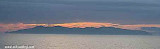
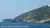
Capo Sagro is located at 11 NM. S Finocchiarola islands. He has a signal station and a semaphore rises N of it. Mount Merizatodio, 778 m high, is 1.5 MN to W Cape and dominates the immediate area.
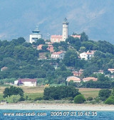
The village of Erbalunga, situated 1.5 miles SSW of Capo Sagro, stands on the S ...
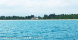
Capraia is one of the seven islands of the Tuscan Archipelago, on the road between Cape Corsica and Elba. It is an island of 335 inhabitants (the Capraiesi) of the Province of Livorno. It lies 64 km from Livorno, 37 km from Gorgona and 31 km from Corsica. Its area is 19 km2. It has ...
This lighthouse, commissioned in 1864, is located two kilometers inland to the tips of Alistro, at 1300 m. But report no particular danger, yet it is an essential reference point between Bastia and Solenzara, flat area and lagoon. The tower, ...
Bravone is located int the Costa Serena, a unique region, between sea and mountains, halfway between Bastia and Porto-Vecchio, at the mouth of the riverTavignano, closes S of the lagoon. This is a small seaside resort along the beach Linguizetta (name of town). It is possible to ...
Beautiful lagoon just north of Bastia, famous since antiquity for its oyster production: it has even, in the center of the lagoon, an island built of oyster shells!
Some fish species grow there before joining the waters of the Mediterranean, the conservatory littoral has bought ...
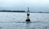
In front of Bastia airport, is an E cardinal to avoid chests used for fueling boats of the Lucciana Oil Terminal. Lucciana Oil Terminal, an offshore pipeline berth, is situated 2 miles S of Pointe d’Arco. The terminal supplies a power station 4 miles SSW. It lies in a depth of ...


 canal 9


 Cale de carénage


 Sheltered harbor, except when E to NE winds - Difficult access by strong NE wind if not easy in any weather.
 Port abrité - Accès difficile par fort vent de NE sinon facile par tous temps. Abrité sauf E à NE.
 La proximité d'une zone marécageuse contigüe au port génère la présence de moustiques et une odeur désagréable.