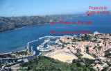
In front of Bastia airport, is an E cardinal to avoid chests used for fueling boats of the Lucciana Oil Terminal.
Lucciana Oil Terminal, an offshore pipeline berth, is situated 2 miles S of Pointe d’Arco. The terminal supplies a power station 4 miles SSW. It lies in a depth of 9.9m and consists of four mooring buoys. A lighted buoy is moored about 0.3 mile E of the berth and marks the approach.
Pilotage is compulsory within 3 miles of the terminal. Pilots are provided from Bastia and entry is controlled by the harbormaster at Bastia.
2012/05/2
Update
Jojo
2012-05-02
Update
Jojo
Face à l'aéroport de Bastia, une cardinale Est pour éviter les coffres servant aux bateaux de ravitaillement en carburant du Lucciana Oil Terminal.
Lucciana Oil terminal, une borne de déchargement pétrolier, est situé à 2 MN au S de la pointe d'Arco. Le terminal fournit une centrale à 4 MN au SSW, qui s'étend à une profondeur de 9,9 m et est entourée de 4 bouées d'amarrage. Une bouée lumineuse est amarrée à environ 0,3 MN à l'E de cette zone.
Le pilotage est obligatoire dans les 3 MN de la borne. Les pilotes viennent de Bastia et l'entrée est contrôlée par la capitainerie du port de Bastia.
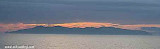
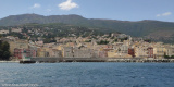
Capo Sagro is located at 11 NM. S Finocchiarola islands. He has a signal station and a semaphore rises N of it. Mount Merizatodio, 778 m high, is 1.5 MN to W Cape and dominates the immediate area.
The village of Erbalunga, situated 1.5 miles SSW of Capo Sagro, stands on the S ...
Capraia is one of the seven islands of the Tuscan Archipelago, on the road between Cape Corsica and Elba. It is an island of 335 inhabitants (the Capraiesi) of the Province of Livorno. It lies 64 km from Livorno, 37 km from Gorgona and 31 km from Corsica. Its area is 19 km2. It has ...
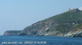
Located between Marines de Sisco and Erbalunga, this point is well known to divers. Cape Sagro is an anchorage where the ancient Roman fleet landed the goods for this part of Cap Corse.
This site is of outstanding beauty and it is not unusual to see diving teams of experienced ...
The Gulf of Saint Florent form a large body of water open to the North to NW winds, but sheltered by the mountains Libeccio of Balagne. Strong wind blows from east sometimes jump off the mountain which is extended by the Cap Corse and a rise in the Gulf chop rather unpleasant.
The ...
Its geographical location makes it a safe shelter against the prevailing winds and waves, especially the libeccio, that often blows on the Cap Corse. By east wind there are chop and surf in the outer harbor, that must be considered.
Easy access through an inlet NE, it is recommended ...


 In front of Bastia airport, is an E cardinal to avoid chests used for fueling boats of the Lucciana Oil Terminal.
")
 Face à l'aéroport de Bastia, une cardinale Est pour éviter les coffres servant aux bateaux de ravitaillement en carburant du Lucciana Oil Terminal.