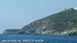
Phare et Sémaphore d'Alistro.

Phare et Sémaphore d'Alistro.

To precisely geolocate this site. Update if necessary.

Localisation

Phare et Sémaphore d'Alistro.
LatitudeLongitude
DMS------
DM------
DD------

Characteristics

Lighthouse

Description

Amer remarkable on the road South.

This lighthouse, commissioned in 1864, is located two kilometers inland to the tips of Alistro, at 1300 m. But report no particular danger, yet it is an essential reference point between Bastia and Solenzara, flat area and lagoon.
The tower, built 50 meters of a semaphore, an adjacent building containing two units of guards.

His fire to two outbursts 10s is lit by a lamp of 1800 W. Perched 96 meters above sea level, it has a luminous range of 23 miles (42 km).

It is guarded but not be visited.

2012/05/3
Update
Jojo
Phare et Sémaphore d'Alistro.
2005:07:23 10:42:35
2012-05-03
Update
Jojo
Amer remarquable sur le route du Sud.

Ce phare, mis en service en 1864, est situé à deux kilomètres à l'intérieur des terres sur les hauteurs d'Alistro, à 1300 m. Ne signalant aucun danger particulier, il est pourtant un point de repère indispensable entre Solenzara et Bastia, zone plate et lagunaire.
La tour, construite à 50 mètres d'un sémaphore, jouxte un bâtiment abritant deux logements de gardiens .

Son feu à 2 éclats 10s est éclairé par une lampe de 1800 W. Perché à 96 mètres au-dessus du niveau de la mer, il a une portée lumineuse de 23 milles (environ 42 km).

Il est gardé mais ne se visite pas.

2012/05/3
Update
Jojo
Ebook

Est Corse - East Corsica

  • 34 sites
  • 69 photos
  • publication date: 25 Jul 2024
  • .pdf file size: 21 Mb
Share your comments or photos on "Phare et Sémaphore d'Alistro."

Sites around Phare et Sémaphore d'Alistro.

Flying distances - Direct line

Cap Sagro - Bastia

29nm
354°
Capo Sagro is located at 11 NM. S Finocchiarola islands. He has a signal station and a semaphore rises N of it.
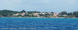
Mount Merizatodio, 778 m high, is 1.5 MN to W Cape and dominates the immediate area. The village of Erbalunga, situated 1.5 miles SSW of Capo Sagro, stands on the S ...
6 May 12
Jojo

Marine de Bravone

3.6nm
169°
Bravone is located int the Costa Serena, a unique region, between sea and mountains, halfway between Bastia and Porto-Vecchio, at the mouth of the riverTavignano, closes S of the lagoon. This is a small seaside resort along the beach Linguizetta (name of town).
It is possible to ...
3 May 12
Jojo

Port de Campoloro - Taverna

4.8nm
Sheltered harbor, except when E to NE winds - Difficult access by strong NE wind if not easy in any weather.
The harbor water is very dirty!

     464 b. of which 100 visit.
     Basin Draught: 2.5 m.
     ...
3 May 12
Jojo

Etang et tour de Diane

7nm
174°
Beautiful lagoon just north of Bastia, famous since antiquity for its oyster production: it has even, in the center of the lagoon, an island built of oyster shells!

Some fish species grow there before joining the waters of the Mediterranean, the conservatory littoral has bought ...
3 May 12
Jojo

Isola Capraia

48nm
14°
Capraia is one of the seven islands of the Tuscan Archipelago, on the road between Cape Corsica and Elba. It is an island of 335 inhabitants (the Capraiesi) of the Province of Livorno. It lies 64 km from Livorno, 37 km from Gorgona and 31 km from Corsica. Its area is 19 km2. It has ...
26 Feb 14
marchew

Plage près de Casabianda

9.8nm
180°
This long beach is one of the Penitentiary Casabianda, open-air prison.

Created in 1880, the Penitentiary Casabianda is closed only by meadows, orchards, eucalyptus forests, sea and sun.

It is not advisable to stop there, most of this area is not sheltered at all!
3 May 12
Jojo