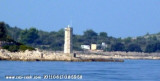
Borak is the small port located on the NE coast of the island, it hosts the small ferry (Ferry and Ferry Trogir Seget Donji). We can anchor off the port less than 10 m, for lunch as this anchorage is exposed to SE and NE.
2011/08/18
Update
Croatia
Le petit port Borak est situé sur la côte NE de l'île, il accueille les petits traversiers (Ferry de Trogir et Ferry de Seget Donji).
On peut mouiller devant le port par moins de 10 m, pour le déjeuner car ce mouillage est exposé au SE et NE.
2011/08/18
Update
Croatia
2011:08:17 09:04:32
2011-08-18
Update
Croatia
View of the village, port and the anchoring area in front of it.
Ciovo is an island in the center of the Dalmatian archipelago. This is an area of 28.8 acres (15.3 km length, width of 3.5 km). It culminates at 218 m (Mount Rudin). O. Ciovo forms the SW side of the entrance and inner part of Kastelanski Zaliv. At East side, Ciovo is 2km from ...
Island accessible only by sea. It is long about 3 m long by 2 m wide. It is 2 M NW of otok Solta.Its area is 12.07 km ² and its highest point is 178 m.It is separated from the mainland by Drvenicki Kanal. The coast of this beautiful island has remained intact and is made of many ...
Otok Zirje
is the farthest and the largest island in the Sibenik archipelago. It is long of 6,5 NM (NW/SE) and 1,4 NM wide. The main village, Zirje, is located in the middle of the island. A small port, luka Muna, on the coast N of Zirje, home to the ferry that connects the ...
Otok Svetac (Andrija), 305m high, lies 13 miles ESE of Otocic Jabuka and is generally steep-to. The coast of the island is rocky and reddish in color on the NW side. Its SW end is fronted by a few rocks. Hrid Kamik, a dark and jagged above-water rock, lies 0.7 mile W of the SW extremity ...
Very close to Drvenik Veli (1 M), Drvenik Mali, the W Drvenik Veli, made 2 M in E and W 1 M to its widest point. The coast is cut and the sea around the island is shallow. Its highest point is 79 meters high. There is a small port on the NE coast of the island. The ...


 Borak is the small port located on the NE coast of the island, it hosts the small ferry (Ferry and Ferry Trogir Seget Donji).
 Le petit port Borak est situé sur la côte NE de l'île, il accueille les petits traversiers (Ferry de Trogir et Ferry de Seget Donji).
 View of the village, port and the anchoring area in front of it.