Le Cap d'Ail marque la séparation entre les baies de Beaulieu et de Monaco. Les abords étant malsains, il faut s'en écarter assez largement. Le cap Martin est couvert de pins d'où émerge un sémaphore blanc sur les hauteurs.
The Presqu'ile de Saint Hospice , 40m high, forms a peninsula which extends E from the center of the E side of the Cap Ferrat promontory. It is surmounted by a chapel and a conspicuous tower Pointe Saint Hospice, located 1.2 miles NE of the Cap Ferrat Light, is the E extremity of ...
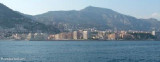
Mento is a small harbor, lies 2 miles NE of Cap Martin. It is protected by two jetties and is used by fishing boats and yachts. The town stands in an amphitheater which is situated on a small promontory at the NE end of a beach. A square tower stands on the extremity of the promontory, ...
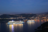
Rade de Villefranche is entered between Pointe des Sans Culottes, the SE extremity of the Mont Boron promontory, and Pointe Malalongue, the SW extremity of Cap Ferrat, 1 mile SE. The bay extends N for 1.5 miles and offers sheltered anchorage to vessels of any size. It is used by vessels ...
Port Cap-d'Ail is situated just W of Monaco with the franch-monegasque boader runing along the E side of the port. 253 berths tel 04 93 41 95 93 Fax 04 93 78 98 28Beware in strong E or W winds there is a strong swell and surf at the head of sea-wall. Les plages Plage Marquet


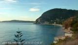
 La plage Mala est nichée dans les rochers où se mêlent galets et sable fin.
 La spiaggia Mala è inserata nelle scoglie dove il fondo è fato di ghiai e di sabbia.