Le Cap d'Ail marque la séparation entre les baies de Beaulieu et de Monaco. Les abords étant malsains, il faut s'en écarter assez largement. Le cap Martin est couvert de pins d'où émerge un sémaphore blanc sur les hauteurs.
The Presqu'ile de Saint Hospice , 40m high, forms a peninsula which extends E from the center of the E side of the Cap Ferrat promontory. It is surmounted by a chapel and a conspicuous tower Pointe Saint Hospice, located 1.2 miles NE of the Cap Ferrat Light, is the E extremity of ...
Mento is a small harbor, lies 2 miles NE of Cap Martin. It is protected by two jetties and is used by fishing boats and yachts. The town stands in an amphitheater which is situated on a small promontory at the NE end of a beach. A square tower stands on the extremity of the promontory, ...
Entrance facing West-Monaco Oceanographic Museum on overthang above port entrance; difficult access in strong E/SE winds (dangerous in force 5 and over).
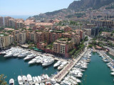
A sovereign and independent state, the Principality of Monaco has borders on its landward side with several communes of the French Department of the Alpes-Maritimes. Its surface area is 485 acres, of which nearly 100 were recovered from the sea during the course of the last twenty ...


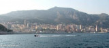
 Cap d'Ail et sur la droite Monaco.

 Port Cap-d'Ail is situated just W of Monaco with the franch-monegasque boader runing along the E side of the port.
 Le port de Cap d'Ail est situé à l'W du rocher de Monaco, la frontière franco-monégasque délimitant la façade E du port.
 Il porto di Cap d'Ail è situato all'W della rocca di Monaco, la frontiera franco-monegasque delimita l'E del porto.