Rade de Villefranche sur Mer

Rade de Villefranche sur Mer

To precisely geolocate this site. Update if necessary.

Localisation

Rade de Villefranche sur Mer
LatitudeLongitude
DMS------
DM------
DD------

Characteristics

Coast
Grass
Diving
Restricted

Description

Rade de Villefranche sur Mer
Vue sur la ville de Villefranche et son port.
A gauche le fort Du Mont Alban.
View on Villefranche city and its harbor.
On the left, top of the hill, the Mont Alban castle.
2004-05-11
Bearing:300°
2007-07-11
Update
Mobile
Ebook

Côte d'Azur - French Riviera

  • 309 sites
  • 647 photos
  • publication date: 6 Jul 2023
  • .pdf file size: 252 Mb
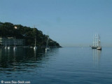
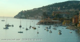
Rade de Villefranche is entered between Pointe des Sans Culottes, the SE extremity of the Mont Boron promontory, and Pointe Malalongue, the SW extremity of Cap Ferrat, 1 mile SE. The bay extends N for 1.5 miles and offers sheltered anchorage to vessels of any size. It is used by vessels that cannot enter Nice.
The W coast of the bay is dominated by the promontory of Mont Boron. The E coast is formed by the rugged and moderately- elevated promontory of Cap Ferrat.
Cap Ferrat Light is shown from a structure, 32m high, standing close N of Pointe Malalongue. A large hotel, very prominent from seaward, stands 0.2 mile E of the light. A prominent signal station surmounts the summit of Cap Ferrat, which is 138m high and stands 0.5 mile N of Point Malalongue.
Anse de l'Espalmador, at the E side of the bay, offers shelter from E winds.

Caution


Speed is limited to 5 knots within an area which extends 1 mile S from the head of the bay.
Anchoring, fishing, and diving prohibited areas, the limits of which are shown on the chart, lie in the vicinity of Pointe des Sans Cullottes; in the vicinity of the shore, close NNW of Pointe Malalongue; and SW of Cap Ferrat. They extend up to 1.5 miles seaward.
This bay may sometimes be used by sea planes fighting forest fires.
2011/07/17
Update
Atoi
Rade de Villefranche sur Mer
2010:09:10 16:03:06
2011-07-18
Update
dd
Superbe rade et bon abri sauf par Sud-Ouest.
Zone de mouillage au Nord Est de la baie. Fonds de 7m.
2007/12/16
Update
Le centre de la rade est utilisé par les bateaux de croisière. Mouillage interdit pour la plaisance. Il faut mouiller au fond de la rade ou sur la côte Est.
2011/07/18
Update
dd
Rade de Villefranche , 21.10.2014
2014/11/12
Update
Rade de Villefranche sur Mer
2014:10:21 07:21:01
2014-11-12
Update
Share your comments or photos on "Rade de Villefranche sur Mer"

Sites around Rade de Villefranche sur Mer

Flying distances - Direct line

Baie de Cannes

16nm
233°
Cannes bay is located between Pointe de l'Aiguille and Cap de la Croisette, 4 miles ENE, from which the islands "Les Îles de Lerins"  extends up to 2 miles. The E side of the gulf is occupied by the town and port of Cannes well known by it's film festival, where the houses form ...
4 Jul 12
Atx

Cap d'Ail - Cap Martin

6.1nm
60°
Le Cap d'Ail marque la séparation entre les baies de Beaulieu et de Monaco. Les abords étant malsains, il faut s'en écarter assez largement.
Le cap Martin est couvert de pins d'où émerge un sémaphore blanc sur les hauteurs.
1 Dec 07

Baie de Beaulieu

2.2nm
81°
The Presqu'ile de Saint Hospice , 40m high, forms a peninsula which extends E from the center of the E side of the Cap Ferrat promontory. It is surmounted by a chapel and a conspicuous tower Pointe Saint Hospice, located 1.2 miles NE of the Cap Ferrat Light, is the E extremity of ...
16 Dec 07

Port de la Darse

0.5nm
330°
The port Darse S (South Dock) is located on the W side of the bay, S of the Villefranche Citadelle. Tel 04 93 01 70 70 Fax 04 93 76 92 33 500 pl. (<30 m)
29 Mar 12

Anse de l'Espalmador

0.4nm
48°
Zone importante de mouillage surtout avec du vent d'Est. On peut mouiller également- un peu plus au nord: anse Grassuet- au sud: anse de Passable : un peu de sable et beaucoup d'herbiers
17 Oct 14

Port de la Santé

0.6nm
348°
The harbourg of La Sante, on the W coast of the roads to the N of the citadel, shelters fishing boats, and in the southern part of it is a terminal with a landing stage for the launches providing the ferry service for the passenger cruise ships anchored in the roads. 36 berths (<15 ...
13 Nov 10