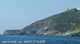
The Revellata lighthouse (he white light: two pieces 10 sec.), 97m high, is the focal point of most routes from the mainland. The fire at the end of the tip is visible in clear weather until more than 24 miles and its radio beacon can be heard 100 miles, almost from the mainland coming to the Riviera.
He was commissioned in 1844. The lighthouse beacon sector from Ile Rousse to the north to the Gulf of Girolata south.
2012/05/11
Update
Jojo
Le phare de la Revellata (le feu blanc: 2 éclats 10 sec.), haut de 97m, est le point de convergence de la plupart des routes venant du continent.
Le feu à l'extrémité de la pointe est visible par temps clair jusqu'à plus de 24 milles et son radio phare est audible à 100 milles, soit presque au départ du continent en venant de la côte d'Azur.
Il a été mis en service en 1844. Le phare balise le secteur depuis l'Ile Rousse au nord jusqu'au golfe de la Girolata au sud.
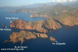
The nature reserve, which is part of the Regional Natural Park of Corsica, occupies the Scandola peninsula, an impressive, porphyritic rock mass. The vegetation is an outstanding example of scrubland. Seagulls, cormorants and sea eagles can be found there. The clear waters, with their ...
Capo Sagro is located at 11 NM. S Finocchiarola islands. He has a signal station and a semaphore rises N of it. Mount Merizatodio, 778 m high, is 1.5 MN to W Cape and dominates the immediate area.
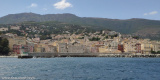
The village of Erbalunga, situated 1.5 miles SSW of Capo Sagro, stands on the S ...
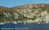
West of Calvi, Porto Vecchio bay, (not to be confused with the city to the south of Corsica) extends deep into the shore steep and high. It offers good shelter from the north wind in the East, but no by Libeccio. Beware of rocks, 17m high, in the southern part which ...
Remarkable
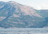
peninsula west of Calvi, advancing 6.5 km into the sea and 150 m high
and supporting the flagship of the same name, one of the most important
of Corsica. The
"grotte des veaux marins" ("Cave of seals") W on the cliff is home unfortunately monk seal ...
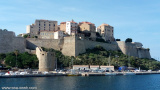
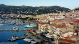
The Citadel was founded in 1268 by the Genoese and helped to push many attacks. The last date of August 1794 which made 6000 English siege of the city. It is said that Christopher Columbus was born in Calvi houses around the harbor which provide small alleys connected by staircases. Beautiful ...
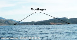
N cap CAVALLO, Nichiareto bay offers a suitable anchorage by Libeccio, but none by Mistral. It is recommended to anchor or in front of the beach by 6 to 7 m on a sandy bottom, rocks and seaweed, just in the east of the small point Bianca where protection against Libeccio ...


 The Revellata lighthouse (he white light: two pieces 10 sec.), 97m high, is the focal point of most routes from the mainland.
 Le phare de la Revellata (le feu blanc: 2 éclats 10 sec.), haut de 97m, est le point de convergence de la plupart des routes venant du continent.