Otok Vir

Otok Vir

To precisely geolocate this site. Update if necessary.

Localisation

Characteristics

Coast

Description

Otok Vir
Otok Vir
2011-03-31
Update
Anonymous
Otok Vir
Otok Vir
Skoljic
2011-07-21
Update
Jojo
Otok Vir
Otok Vir
2011-07-21
Update
Jojo
Ebook

Zadarska županija (Zadar county)

  • 85 sites
  • 112 photos
  • publication date: 11 Jul 2023
  • .pdf file size: 39 Mb
The island of Vir is one of the 300 islands of Zadar archipelago.
Vir island is located SW Pag, it is 25 kilometers north of Zadar and it has an area of 22.38 square kilometers. It rises gently from the sea to a bare and double summit, (Bandira) 112m high, with reminds of fort.

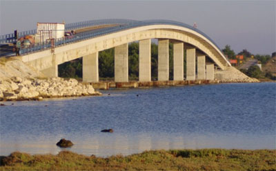
A bridge, that was built in 1976 and that has a vertical clearance of 9 m, spans the channel of Privlaki Gaz, and connects Otok Vir to the mainland. The bridge  It is very shallow (about 1 m). It is 27m wide and is marked by beacons.

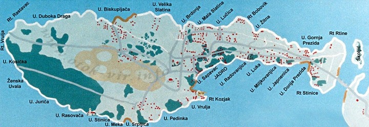
The biggest village Vir is situated on the hill above the sand bay Sapavac.
Vir Island is also commonly known as the ‘island of contrasts’ because of the number of resort houses, and tourists staying here.

Vir Island has sandy and pebbly beaches with numerous bays and inlets with piers.

There is also a small islet nearby called Skoljic that is covered in pine forests and has a long sandy beach.

2011/07/22
Update
Jojo
Le pont de Vir.
2011/07/21
Update
Jojo
moj vir mnogo volim da idem na more i kada imam nogo drustva volim sve  oko sebe  koji postoje idem u hrvatsko na more  kod moje bake nade ima ih mnogo mojihprijatelja i mnogo volim da se kupam ja sam mnoigo se nezno kupam
2012/06/12
Update
Vir est une des 300 îles de l'archipel de Zadar.
L'île de Vir se trouve au SW de celle de Pag, à 25 km au N de Zadar. Elle a une surface de 22,38 km².
Son plus haut sommet (Bandira) s'élève à 112 m, avec les ruines d'un fort.

Elle est reliée au continent par un pont routier (Tirant d'air 9 m), qui fut construit en 1976 et qui enjambe le chenal de Privlaki Gaz. Celui-ci est très peu profond (1 m environ). Il est large de 27 m et est balisé.

Le plus grand village (Vir) est situé sur une colline au-dessus de la baie sablonneuse de Sapavac.

L'île de Vir est connue comme "l'île des contrastes" en raison du nombre de maisons de villégiature, et des touristes séjournant ici.
Vir possède des plages de sable et de galets avec de nombreuses baies et criques avec des quais.
Il y a aussi un petit îlot voisin appelé Skoljic qui est couvert de forêts de pins et possède une longue plage de sable.

2011/07/22
Update
Jojo
Share your comments or photos on "Otok Vir"

Sites around Otok Vir

Flying distances - Direct line

Kanal Nove Povljane Vir

1.6nm
49°
Kanal Nove Povljane, entered between Otok Vir and the SE end of Otok Pag, leads 5 miles SE into Ninski Zaliv.
Shoals at the inner end of this channel restrict the fairway to a width of about 250m, with a controlling depth of 8m. Vessels with a draft of over 6m are advised not to ...
23 Jul 11
Jojo

Rivanjski Kanal

9.1nm
199°
Rivanjski Kanal continues NW from the N end of Srednji Kanal and leads between Otok Rivanj andOtok Sestrunj.
It is generally used by vessels proceeding between Srednji and Zadarski Kanals.
Otocic Tri Sestrice, a group of islets and rocks, extend up to 2 miles NW of Rt Zanavin, ...
9 Sep 11
Jojo

Otok Olib Zadar

13nm
290°
Otok Olib is located E of O. Silba. It belongs to Zadar archipelago.The island has been inhabited since Roman times. The residents bought their island in 1900. The only village on the island was established around the port.
To the east of the island you will find some small hidden ...
27 Jul 11
Jojo

Ninsko Ljubacki Kanal Zadar

5.4nm
94°
Ninsko-Ljubacki Kanal, a tortuous channel, connects the SE end of Kanal Nove Povljane with Ljubacka Vrata. This channel leads through the deep inlets which indent the SE coast of Otok Pag, on the NW side, and the mainland, on the SE side.
It is entered between Rt Prutna,which is ...
23 Jul 11
Jojo

Olipski Kanal

15nm
288°
Olipski Kanal leads NNW between the E side of Otok Silba and the W side of Otok Olib and merges into the N end of Pohlipski Kanal.
This channel is deep and has a minimum navigable width of 0.7 mile. It is often used by vessels proceeding to and from Zadar.
Good anchorage is ...
18 Sep 11
Jojo

Privlacki Zaton Vir

1.7nm
152°
Privlacki Zaton, a bay, lies between Rt Artic and Rt Kozjac, 2 miles NW.
Anchorage can be taken within this bay, in depths of 11 to 20m, soft mud, under the S shore of Otok Vir.
22 Jul 11
Jojo