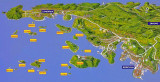
Korcula is an island located in the Dubrovnik-Neretva County of Croatia. The island has an area of 279 km2; 46.8 km long and on average 7.8 km wide — and lies just off the Dalmatian coast.
The island of Korčula belongs to the central Dalmatian archipelago, separated from the Pelješac peninsula by a narrow strait of Pelješac, between 900 and 3,000 m wide. The island lies on the N side of Lastovski kanal. It is the sixth largest Adriatic island with a rather indented coast. The highest peaks are Klupca, 568 m above sea level and Kom, 510 m high.
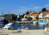
Korčula town has mooring facilities. The western harbour gives shelter from wind though not against the ‘bora’
and north-westerlies. Boat owners are advised to shift to the eastern
harbour or to Luka Cove. The port is open to international seaborne
traffic as a permanent Port of entry; it offers all types of repairs to hulls and engines at the Brodograditelj Shipyard.
2011/05/12
Update
Jojo
Korcula est une île située dans le comté de Dubrovnik-Neretva de la Croatie. L'île a une superficie de 279 km2; 46.8 km de long et en moyenne 7.8 km de large - et se trouve juste au large de la côte dalmate. L'île de Korcula appartient à l'archipel de Dalmatie centrale, séparée de la presqu'île de Peljesac par le détroit de Pelješac, (entre 900 et 3.000 m de large). L'île est située sur le côté N du kanal Lastovski. C'est la sixième plus grande île de l'Adriatique avec une côte assez en retrait. Les plus hauts sommets sont Klupca, 568 m d'altitude et Kom, 510 m de haut. La ville de Korcula a des installations de mouillage. Le port de l'Ouest offre un abri contre le vent mais pas contre la «Bora» et le vent de NW. Les propriétaires de bateaux sont invités à aller vers le port oriental ou Luka Cove. Le port est ouvert au trafic maritime international en tant que Port d'entrée permanent, il offre tous les types de réparations de coque et de moteurs au chantier naval de Brodograditelj.
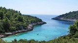
Zaljev Vela Luka is a large bay on the E O. Korcula. Many coves occupy the bay. At the bottom of it is the port of Vela Luka, an active and well sheltered. Easily identifiable by day or night, you can enter this great bay in all weather. Dangers in the general approach are the ...
Zavalatica is located in the middle of the S coast of Korcula. This bay has a small tourist town and small port. This bay is located 12 NM W of Rt Raznjic and 4 NM E of Rt Veli Zaglav which carry a fire every second. No dangers in the approach. It may dock inside the dock. Good ...
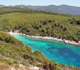
NW from Brna village is Kosirina or Istruga bay hosting a sports and recreation center with two tennis courts, petanque, ping-pong and beach volleyball. We anchor by 5-8 m. Sheltered from all winds.
Brna is a bay and a village on the south coast of the island of Korcula, located 4 km southwest of Smokvica and 20 km south-east of Vela Luka. Can moor at the wharf in the village, but watch portions of the wharf are less than 0.5 m. You can anchor at 7 m at the bottom of the ...
Skoji is a group of islands in Korcula Archipelago, located in Peljesac Channel in Croatia. There are all together 19 small islands that form this archipelago. Their names are : Badija, Kamenjak, Gojak, Planjak, Vrnik, Majsan, Majsanic, Gubavac, Knezic, Bisace, Sutvara, Stupe, Baretica, ...


 Korcula is an island located in the Dubrovnik-Neretva County of Croatia. The island has an area of 279 km2; 46.8 km long and on average 7.8 km wide — and lies just off the Dalmatian coast.
 Korcula est une île située dans le comté de Dubrovnik-Neretva de la Croatie. L'île a une superficie de 279 km2; 46.8 km de long et en moyenne 7.8 km de large - et se trouve juste au large de la côte dalmate.