Otocic Sveti Marko

Otocic Sveti Marko

To precisely geolocate this site. Update if necessary.

Localisation

Otocic Sveti Marko
LatitudeLongitude
DMS------
DM------
DD------

Characteristics

Island / Atoll
Lighthouse

Description

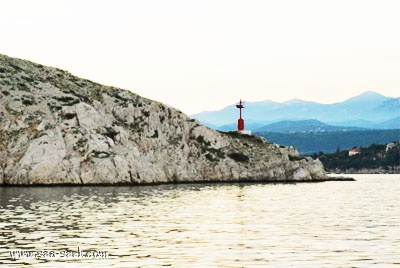
Otocic Sveti Marko, barren and light-colored, lies close off the N extremity of Otok Krk and divides the N part of the fairway into two passages.

The main passage leads NE of the island and is 0.2 mile wide. During strong gales, the current in this channel may attain a rate of 3 knots.
The passage leading SW of the island is suitable only for small craft.
A light is shown from the NE side of Otocic Sveti Marko.

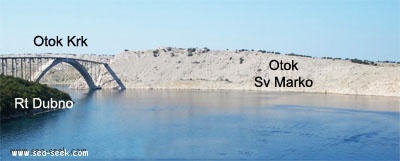
A road bridge spans the two passages of Tihi Kanal at the S end of Otocic Sveti Marko.
The W passage has a vertical clearance of 50m and the E passage, under the center span, has a vertical clearance of 60m.
Southbound vessels using Tihi Kanal are generally given the right of way. Approval to transit Tihi Kanal must be obtained from the Rijeka port authority.
2011/08/2
Update
Jojo
Otocic Sveti Marko
Otocic Sveti Marko
Le feu de Sv. Marko
2011-08-02
Update
Jojo
Otocic Sveti Marko, déserte et de couleur claire, se trouve à proximité de l'extrémité N de Otok Krk et divise la partie N du chenal en deux passages.
Le principal passage mène au NE de l'île et est de 0,2 mile de large. Pendant les vents forts, le courant dans ce canal peut atteindre 3 nœuds.
Le passage menant au SW de l'île ne convient que pour les petites embarcations.
Un feu s'élève du côté NE de Otocic Sveti Marko.
Un pont routier s'étend sur les deux passages de Tihi Kanal, à l'extrémité S d'Otocic Sveti Marko.
Le passage W a une hauteur libre de 50m et le passage E, sous la travée centrale, a une hauteur libre de 60m.
Des navires allant vers le sud en utilisant Tihi Kanal ont généralement le droit de passage. L'approbation du transit Tihi Kanal doit être obtenue auprès de l'autorité du port de Rijeka.
2011/08/2
Update
Jojo
Otocic Sveti Marko
Otocic Sveti Marko
2011-08-02
Update
Jojo
Ebook

Kvarner

  • 120 sites
  • 182 photos
  • publication date: 7 Jul 2023
  • .pdf file size: 69 Mb
Share your comments or photos on "Otocic Sveti Marko"

Sites around Otocic Sveti Marko

Flying distances - Direct line

Tihi kanal

1.3nm
104°
Tihi Kanal, 3 miles long, connects the NW end of Vinodolski Kanal to Rijecki Zaliv.
The channel is deep and tortuous and leads between the mainland and the NE end of Otok Krk.
2 Aug 11
Jojo

Kanal Vela Vrata

14nm
242°
Kanal Vela Vrata connects the N end of Kvarner to Rijecki Zaliv and leads between the N end of Otok Cres, on the E side, and the mainland coast, on the W side.
The channel is deep and clear, the bottom being formed of mud.
31 Jul 11
Jojo

Otok Plavnik Kvarner

17nm
184°
Otok Plavnik lies with Rt Veli Pin, its N extremity, located 0.7 mile E of the E side of Otok Cres and divides Srednja Vrata in its S part into two channels.
This cliffy island is 194m high and partly wooded.
Several small islets lie on a shoal bank which extends about 1.5 miles ...
4 Aug 11
Jojo

Bakarski Zaljev Rijeka

2.4nm
357°
Bakarski Zaljev is a bayalmost closed on the continent, and SE of Rijeca N O. Krk. It is entered 6 NM ESE of Rijeka and is accessible by a channel of 0.3 nm wide at its narrowest point.
It is equipped with facilities for cargo.
There is a shipyard in Kraljevica, an oil terminal ...
31 Jul 11
Jojo

Kanal Krusija

17nm
185°
Kanal Krusija leads to the W of Otok Plavnik.
This channel is frequented because of its steep-to shores and deep passage.
A strong current may occasionally be experienced in this channel, depending on local weather conditions, but this passage is recommended over the one leading ...
4 Aug 11
Jojo

Zaljev Soline Krk

6nm
157°
Zaliv Soline, a nearly landlocked small bay, lies 1.5 miles WNW of Rt Silo and is entered through a narrow channel.
Although there are depths of 10 to 12m over a width of 100m in the entrance, the bay has depths of only 2 to 4m and is used mostly by small craft.
1 Aug 11
Jojo