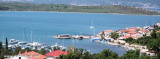
Zaliv Soline, a nearly landlocked small bay, lies 1.5 miles WNW of Rt Silo and is entered through a narrow channel. Although there are depths of 10 to 12m over a width of 100m in the entrance, the bay has depths of only 2 to 4m and is used mostly by small craft.
2011/08/1
Update
Jojo
Zaliv Soline, une petite baie presque enclavée, se trouve à 1,5 milesau WNW de Rt Silo. On y entre par un canal étroit. Bien qu'il existe des profondeurs de 10 à 12m sur une largeur de 100m dans l'entrée, la baie a des profondeurs de seulement 2 à 4m et est surtout utilisée par les petites embarcations.
Kanal Vela Vrata connects the N end of Kvarner to Rijecki Zaliv and leads between the N end of Otok Cres, on the E side, and the mainland coast, on the W side. The channel is deep and clear, the bottom being formed of mud.
Otok Plavnik lies with Rt Veli Pin, its N extremity, located 0.7 mile E of the E side of Otok Cres and divides Srednja Vrata in its S part into two channels. This cliffy island is 194m high and partly wooded. Several small islets lie on a shoal bank which extends about 1.5 miles ...
Tihi Kanal, 3 miles long, connects the NW end of Vinodolski Kanal to Rijecki Zaliv. The channel is deep and tortuous and leads between the mainland and the NE end of Otok Krk.
Kanal Krusija leads to the W of Otok Plavnik. This channel is frequented because of its steep-to shores and deep passage. A strong current may occasionally be experienced in this channel, depending on local weather conditions, but this passage is recommended over the one leading ...
Bakarski Zaljev is a bayalmost closed on the continent, and SE of Rijeca N O. Krk. It is entered 6 NM ESE of Rijeka and is accessible by a channel of 0.3 nm wide at its narrowest point. It is equipped with facilities for cargo. There is a shipyard in Kraljevica, an oil terminal ...
The village offers a marina with space at anchor or dry. But it is crowded and it is difficult to find a place.Danger: entering in the bay to watch the rock Solinji in the center. It is advisable to keep S and then continue to the NW in order to avoid the shoals of Crni.Anchor in ...


 Zaliv Soline, a nearly landlocked small bay, lies 1.5 miles WNW of Rt Silo and is entered through a narrow channel.
 Zaliv Soline, une petite baie presque enclavée, se trouve à 1,5 milesau WNW de Rt Silo. On y entre par un canal étroit.