Kanal Vela Vrata connects the N end of Kvarner to Rijecki Zaliv and leads between the N end of Otok Cres, on the E side, and the mainland coast, on the W side.
The channel is deep and clear, the bottom being formed of mud.
2011/07/31
Update
Jojo
Kanal Vela Vrata relie l'extrémité N de Kvarner à Rijecki Zaliv et s'étend entre la fin N d'Otok Cres, sur le côté E, et le continent, sur le côté ouest. Le canal est profond et clair, le fond étant formé de boue.
The large natural inlet Zaljev Rasa offers the best protection of all sectors of the entire E coast of Istria, while the Bora blows strongly here. This bay is sinking into the earth near 6M, between Rt Ubac and Rt Mulac. The Rijeka Rasa flows into the bottom, creating a current that ...
Otok Unije, a long and irregular shaped island, lies with Rt Vnetak, its SW extremity, located 7 miles NNW of Otok Susak and at W from N O. Losinj from it is separated by Unijski Kanal. The island consists of a chain of partly wooded hills and the summit, 132m high, stands in the ...
Otok Plavnik lies with Rt Veli Pin, its N extremity, located 0.7 mile E of the E side of Otok Cres and divides Srednja Vrata in its S part into two channels. This cliffy island is 194m high and partly wooded. Several small islets lie on a shoal bank which extends about 1.5 miles ...
This area is located between Cape Kamenjak SW Marler and heading to the N. Seven small islands surrounded by rocks and shoals dot the entrance Medulinski Zaljev. Four tags indicate isolated rocks in the W of the bay, their presence is uncertain.The chanel between Rt Munat et ...
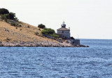
Rt Prestenice is located at the E side of the channel. This point is steep-to, partly wooded, and rises rapidly to the SE. A light is shown from a prominent structure, 13m high, standing on the point.
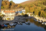
Porozina est un terminal de Ferries sur la côte NW de l'île de Cres, en face de Brestova sur le continent. Baie bien protégée de la Bora et du Sirocco mais exposée aux vents d'W et de SW.


 Kanal Vela Vrata connects the N end of Kvarner to Rijecki Zaliv and leads between the N end of Otok Cres, on the E side, and the mainland coast, on the W side.
 Kanal Vela Vrata relie l'extrémité N de Kvarner à Rijecki Zaliv et s'étend entre la fin N d'Otok Cres, sur le côté E, et le continent, sur le côté ouest.