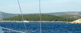
Otocic Smokvica Vela and Mala lies 0.5 mile NW of Rt Movar. A small islet and several rocks lie on a shoal bank which extends up to about 0.5 mile NNE of the N end of this islet.
2011/08/8
Update
JB_06
Otocic Smokvica Vela et Mala s'étendent à 0,5 NM au NW de Rt Movar. Un petit îlot et plusieurs roches se trouvent sur un banc qui s'étend jusqu'à environ 0,5 mile au NNE de l'extrémité N de cet îlot.
2011/08/8
Update
JB_06
Otocic Smokvica Vela and Mala Primosten
Otocic Smokvica Vela et Smokvica Mala vues par le S
Otok Zirje
is the farthest and the largest island in the Sibenik archipelago. It is long of 6,5 NM (NW/SE) and 1,4 NM wide. The main village, Zirje, is located in the middle of the island. A small port, luka Muna, on the coast N of Zirje, home to the ferry that connects the ...
Ciovo is an island in the center of the Dalmatian archipelago. This is an area of 28.8 acres (15.3 km length, width of 3.5 km). It culminates at 218 m (Mount Rudin). O. Ciovo forms the SW side of the entrance and inner part of Kastelanski Zaliv. At East side, Ciovo is 2km from ...
Otok Svetac (Andrija), 305m high, lies 13 miles ESE of Otocic Jabuka and is generally steep-to. The coast of the island is rocky and reddish in color on the NW side. Its SW end is fronted by a few rocks. Hrid Kamik, a dark and jagged above-water rock, lies 0.7 mile W of the SW extremity ...
Wide bay sheltered from all winds, with multiple opportunities for mooring anchor. A marina excellent high-end with all services but expensive. In the middle of the bay lies the island, connected to the mainland by a causeway, on which the village of Rogoznica is built. An old ...
Zlarinski Kanal leads along the SW side of Otok Zlarin and is entered midway between Rt Rat and Otocic Komorica, a small islet marked by a light, 1.5 miles SW. This channel is sometimes used as an alternate route to Sibenik by vessels entering Sibenska Vrata, the middle passage, ...
Island accessible only by sea. It is long about 3 m long by 2 m wide. It is 2 M NW of otok Solta.Its area is 12.07 km ² and its highest point is 178 m.It is separated from the mainland by Drvenicki Kanal. The coast of this beautiful island has remained intact and is made of many ...


 Otocic Smokvica Vela and Mala lies 0.5 mile NW of Rt Movar. A small islet and several rocks lie on a shoal bank which extends up to about 0.5 mile NNE of the N end of this islet.
 Otocic Smokvica Vela et Mala s'étendent à 0,5 NM au NW de Rt Movar. Un petit îlot et plusieurs roches se trouvent sur un banc qui s'étend jusqu'à environ 0,5 mile au NNE de l'extrémité N de cet îlot.