From both sides of the Øresund trait, the bridge is a striking spectacle. The 204 m high pylons are visible from far away. The Øresund fixed link is 16 km long and consists of a 8 km long bridge, a tunnel and an artificial island. You can cross the bridge either by car or by train
2010/09/26
Update
Des deuc côtés du détroit de l'Oresund, the pont est un spectacle étonnant. Les pylônes de 204 mètres sont visibles depuis loind. Le lien entre les deux pays fait 16 km et est composée d'un pont de 8 km, d'un tunnel et d'une île artificielle. Vous pouvez traverser le pont en voiture ou en train.
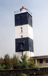
Tarapur Point is bordered by foul ground extending about 0.8 mile W; a narrow reef extendsabout 2.8 miles NNW from the N extremity of the point. A light is shown from a white square masonry tower, 23m high with black bands, on the N extremity of the point.
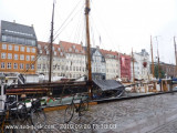
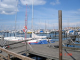
Nyhavn which means "New harbour" in Danish is a canal situated in the Copenhagen center. It has been built at the end of XVII and is now one of the most famous place in the city. The commercial boats are now replaced by beautiful sailing boats. Along the harbour there are many restaurant. ...


 From both sides of the Øresund trait, the bridge is a striking spectacle.
 Des deuc côtés du détroit de l'Oresund, the pont est un spectacle étonnant. Les pylônes de 204 mètres sont visibles depuis loind. Le lien entre les deux pays fait 16 km et est composée d'un pont de 8 km, d'un tunnel et d'une île artificielle. Vous pouvez traverser le pont en voiture ou en train.