Kobenhavn

Kobenhavn

To precisely geolocate this site. Update if necessary.

Localisation

Kobenhavn
LatitudeLongitude
DMS------
DM------
DD------

Characteristics

Water
Fuel
First aid
Shipyard
Harbour

Description

Largeharbor protected by a breakwater.
2011/07/30
Update
cognent
Grand port de commerce protégé par une digue.
2011/07/30
Update
cognent
Kobenhavn
2011-07-30
Update
cognent
Ebook

Baltic sea

  • 84 sites
  • 71 photos
  • publication date: 11 Jul 2023
  • .pdf file size: 70 Mb
Share your comments or photos on "Kobenhavn"

Sites around Kobenhavn

Flying distances - Direct line

The Little Mermaid

0.9nm
194°
The famous little Mermaid of Eriksen in danish "den lille havfrue" 
26 Sep 10

Tarapur Point (W India)

1.2nm
145°
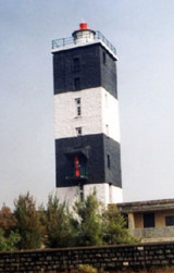
Tarapur Point is bordered by foul ground extending about 0.8 mile W; a narrow reef extendsabout 2.8 miles NNW from the N extremity of the point.
A light is shown from a white square masonry tower, 23m high with black bands, on the N extremity of the point.
1 Mar 12
Jojo

Nyhavn

1.7nm
199°
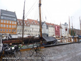
Nyhavn which means "New harbour" in Danish is a canal situated in the Copenhagen center. It has been built at the end of XVII and is now one of the most famous place in the city. The commercial boats are now replaced by beautiful sailing boats. Along the harbour there are many restaurant. ...
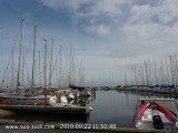
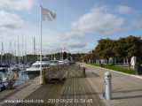
26 Sep 10

Vedbaek Havn

8.5nm
352°
Vedbaek harbor is situated in the city of Rudersdal.
28 Sep 10

Rungsted

10nm
349°
The Rungsted harbor is situated in the city of Horsholm on the Danish Riviera
28 Sep 10

Horsholm

10nm
349°
Provide here details of the site. You can put text or images.
28 Sep 10