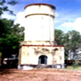
Ramaypatnam Light, from which a radiobeacon transmits, is shown from a hexagonal concrete tower lying on the coast 0.8 mile NE of the church at Ramaypatnam, built in 1870, that served as a land mark for the benefit of ships cruising off the Ramaypatnam coast. The Lighthouse Tower was built in 1982 and the PRB-21 equipment supplied
by M/s Asia Navigation Aids,New Delhi was installed on it. The
lighthouse was commissioned in to service on 26th June1982. The sealed
beam lamps were replaced by Auto Head lights with 12 V 100 W halogen
lamps in February 1996.
Mutapolli Bank, with depths of 6.4 to 11m, lies centered about 11 miles E of Kottapatnam. Overfalls usually mark this bank. Two detached shoals, with depths of 10 to 11m, lie within 5.8 miles SW and three detached shoals, with depths of 9.1 to 11m, lie within 11.3 miles NE of this bank.
Shallinger Shoal, a spit with depths of 3.2 to 4.6m, extends about 2.5 miles NE from the coast, 7.5 miles N of the mouth of the Upputeru River. A detached 5.5m patch lies 1.5 miles S of the NE extremity of Shallinger Shoal.
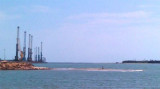
Krishnapatnam or Kistnapatam is a port town in Muthukur mandal of Nellore district in Andhra Pradesh.Krishnapatnam is a major port and market center. It is situated at a distance of 24 km from Nellore City in Nellore District, the southernmost coastal district in the state of ...
Armagon Shoal, with depths ranging from 3 to 9.1m, extends about 15 miles N from a position 1.5 miles NE of Point Pudi. A narrow, detached shoal, about 2.5 miles long, with depths of 10 to 11m, lies close N of the N end of Armagon Shoal. The sea sometimes breaks over the shallowest ...
False Divi Point is a low headland located at the northern end of the Coromandel Coast, in the state of Andhra Pradesh. It is located at the apex of the Krishna River delta and covered by small mangroves. The area is low, swampy and dominated by mangroves.A bank, which dries in ...


 Ramaypatnam Light, from which a radiobeacon transmits, is shown from a hexagonal concrete tower lying on the coast 0.8 mile NE of the church at Ramaypatnam, built in 1870, that served as a land mark for the benefit of ships cruising off the Ramaypatnam coast.
")