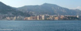
Cap d'Ail - Cap Martin
0.7nm
54°
Le cap Martin est couvert de pins d'où émerge un sémaphore blanc sur les hauteurs.
1 Dec 07
| Latitude | Longitude | |
| DMS | --- | --- |
| DM | --- | --- |
| DD | --- | --- |
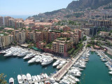
 Port de La Condamine ou Port Hercule au Nord-Est de la principauté.
 Musée Océanographique (amer remarquable).
 A sovereign and independent state, the Principality of Monaco has borders on its landward side with several communes of the French Department of the Alpes-Maritimes. Its surface area is 485 acres, of which nearly 100 were recovered from the sea during the course of the last twenty years. Monaco lies on a narrow coastal strip, which sometimes rises vertically upwards with its highest point at 206 feet. Its width varies between .65 miles and a mere 382 yards. Its coastline is 2.5 miles long. The Principality has only one commune, Monaco, whose limits are the same as those of the state.
Within 24h of berthing, you must report to the Société d'exploitation des ports de Monaco, duly completed together with ship's papers and pay the necessary harbour fees. On saturdays, sundays, and public holidays, you are requested to report to the harbourmaster's office.


 Stato soveregno e independante, la principato è circondata di numerosi comune francese di Alpes-Maritimes.
Ebook | Côte d'Azur - French Riviera
|