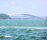
Miami Beach (Florida)
6.2nm
173°
The city is ...
8 Apr 10
Joëlle
| Latitude | Longitude | |
| DMS | --- | --- |
| DM | --- | --- |
| DD | --- | --- |


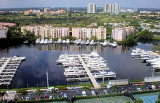
 Maule Lake is not a private lake. Anchorage is allowed by the property
As you enter Maule Lake itself, continue straight out into the wider water. avoid the S point at the end of the canal. A rocky shoals abuts this promontory.
Maule Lake is mostly deep, with the exception of some shoal water abutting the N banks. Cruise SW into the lake's miwaters before cutting W to the harbor. This procedure will avoid the charted finger of shallower water that streches S from the N Baks.
Anchorage located near the center section of Maule Lake, west of unlighted daybeacon #54, with a minimum depth of 6 feet.
 Laissez le ICW S du # 54 et naviguer dans le milieu du canal, le plus au nord du passage W à Maule Lake. Avancez strictement au ralenti! Le passage est parallèle à un grand immeuble résidentiel sur la rive S.
Mouillage situé à proximité du centre du lac Maule, à l'W de la balise #54, avec une profondeur minimum de 1,8 m.
Ebook | US - East coast
|