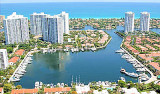
Located directly on the Intracoastal Waterway, the Turnberry Isle Marina features 117 slips accommodating vessels up to 180 feet. Private and safeguarded with 24-hour security, The Marina provides all the essentials your vessel requires.
Located midway between Miami and Fort Lauderdale, Turnberry Isle Marina Yacht Club is just minutes away from the shops of the Aventura Mall, world-class restaurants, beautiful beaches, and Gulfstream Park Racing and Casino.
Situé directement sur l'Intracoastal Waterway, le Turnberry Isle Marina dispose de 117 places et peut recevoir des bateaux jusqu'à 54 m. Privée et protégée avec une sécurité de 24 heures, la marina offre toutes les fonctions essentielles dont votre navire a besoin. Située à mi-chemin entre Miami et Fort Lauderdale, Turnberry Isle Marina Yacht Club est à quelques minutes des boutiques du centre commercial Aventura, avec des restaurants de classe mondiale, de belles plages, et Gulfstream Park Racing et Casino.
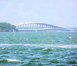
Miami Beach occupies the barrier beach that separates the ocean from the upper part of Biscayne Bay and is also an important yachting center. A number of causeways, with bridges over the channels, form good highway connections with Miami and the mainland communities. The city is ...
Key Biscayne is an island located in Miami-Dade County, Florida, United States, between the Atlantic Ocean and Biscayne Bay. It is the southernmost of the barrier islands along the Atlantic coast of Florida, and lies south of Miami Beach and southeast of Miami. The Key is connected ...
Elliott Key is the northernmost of the true Florida Keys (those 'keys' which are ancient coral reefs lifted above the present sea level), and the largest key north of Key Largo. It is located entirely within Biscayne National Park. It is bordered by the Atlantic Ocean to ...
To reach the anchorage of Dumfoundling Bay, depart the waterway once abeam of the charted channel leading W, well N of flashing daybeacon #49. Cruise E at idle speed, favoring the N shore. Be sure to set the hook before reaching the charted shoal water at the rear of the cove.We anchor ...
You can access Loggerhead Club & Marina by mile marker 1075.2 on the Intracoastal Waterway. The inlet channel is 4 miles north of Bakers Haulover Inlet and ...


 Located directly on the Intracoastal Waterway, the Turnberry Isle
")
 Situé directement sur l'Intracoastal Waterway, le Turnberry Isle Marina dispose de 117 places et peut recevoir des bateaux jusqu'à 54 m. Privée et protégée avec une sécurité de 24 heures, la marina offre toutes les fonctions essentielles dont votre navire a besoin.