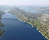
Kanal Malog Stona is a landlocked continuation of Malo More. This channel extends 10.5 miles to the head, narrowing as it progresses. Its SE part is known as Zaliv Malog Stona. The shores of the channel are rocky and steep-to with mountainous terrain closely backing them. Rapid changes in the water level (seiches) of up to 2m occur periodically within Kanal Malog Stona and cause strong currents of variable direction.
2011/05/1
Update
Jojo
Kanal Malog Stona est une continuation du littoral Malo More. Ce canal s'étend sur 10.5 miles et se rétrécis à mesure qu'il progresse. Sa partie sud-est est connue sous le nom de Zaliv Malog Stona. Les rives du canal sont rocheuses et abruptes et sont bordées d'un relief accidenté. Des remontées rapides du niveau de l'eau (seiches) à hauteur de 2m bordent le Kanal Malog Stona et provoquent de forts courants de direction variable.
The narrow sea from Zaliv Klek Neum is 4 NM long and lies at the NE channel Malog Stone. It is surrounded by mountains and is inserted between Rt Rep Kleka and Rt Meded. Depths exceeding 20 meters in most cases. There are several anchorages. The SE part and W peninsula ...
It is the largest and most populated island of the group Elafiten. It rises to 234 m at its N and a prominent hill rises 224 m NW of the SE end. Ruda is a small island that is 0.5 M SE of the NE extremity of the island and Misnjaka, 13 m high, lies close off the NW extremity. ...
Stonski Kanal, a deep inlet, indents the SE end of Poluotok Peljesac at the NW end of Kolocepski Kanal. Its shore rises rapidly on each side and provides protection from NE and SW winds. The village of Brocej is situated on the S shore 3.8 miles within the entrance. It is fronted ...
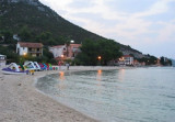
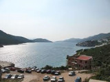
Uvala Klek is a large bay housing a small town famous for its numerous historical monuments. At the bottom of the bay is a great beach and SE of the peak W there is an island (O. Kojestac) with a chapel. We anchored off the beach by about 8 m .
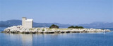
This island is situated at the entrance to Uvala Klek, SE tip W. It wears a small chapel but did not have a lighthouse. It is possible to to pass near the island in N where the funds are 5.5 m.
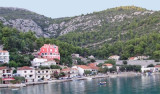
Uvala Duboka is located at Zaliv Klek Neum enter, N Rt Maded. At the bottom of the bay there are few homes and a small dock.We can anchor by 5 to 8 m.Open to SE.


 Kanal Malog Stona is a landlocked continuation of Malo More. This channel extends 10.5 miles to the head, narrowing as it progresses.
 Kanal Malog Stona est une continuation du littoral Malo More. Ce canal s'étend sur 10.5 miles et se rétrécis à mesure qu'il progresse.