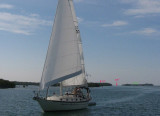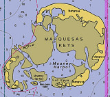

Marquesas Keys (Florida)
17nm
271°
8 Apr 12
Cham
| Latitude | Longitude | |
| DMS | --- | --- |
| DM | --- | --- |
| DD | --- | --- |


")
Ebook | Gulf of Mexico
|
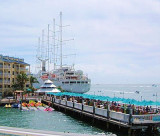
 Municipal Wharf, also known as Mallory Wharf, is 870 feet long and has a deck height of about 7 feet.
Potable water is available with advance arrangements.
Large vessels must depart the berth 45 minutes before sunset except in emergency, or by special arrangement with the Key West Department of
Transportation.
 Le quai municipal, (Mallory Wharf) est long de 261 m et a une profondeur de 2m.
Services: eau potable.
Les grands vaisseaux doivent quitter leur place 45 minute avant le coucher du soleil, sauf en cas d'urgence ou accord spécial avec le
Key West Department of Transportation.